
TRAVEL SANFRANCISCO
( including dayout tour of Yosemite National Park-17-Mile Drive Trip- Muir Woods and Wine Country Tour)

GENERAL INFORMATION-San Francisco is located on the West Coast of the USA at the north end of San Francisco Peninsula. The Peninsula stretches along Pacific Ocean and San Francisco Bay. Several picturesque islands are near and in the San Francisco city are Alcatraz, Treasure Island and the adjacent Yerba Buena Island and small portions of Alameda Island, Red Rock Island, Angel Island. Also the uninhabited Farallon Islands. It is located on a seven-by-seven mile (11 x 11km) square of land, it has population of 8, 15,000. San Francisco (Spanish for "Saint Francis") was founded on June 29, 1776, when colonists from Spain established a fort at the Golden Gate and a mission named for St. Francis of Assisi a few miles away. Upon independence from Spain in 1821, the area became part of Mexico. Under Mexican rule, the mission system gradually ended and its lands became privatized. During Mexican –American War in 1846 the Mexican ceded the territory at the end of war. The California Gold Rush of 1849 brought rapid growth, making it the largest city on the West Coast at the time. Entrepreneurs sought to capitalize on the wealth generated by the Gold Rush. Early winners were the banking industry, with the founding of Wells Fargo in 1852 and the Bank of California in 1864. After three-quarters of the city was destroyed by the 1906 earthquake and fire, San Francisco was quickly rebuilt. San Francisco attracts the fifth-highest number of foreign tourists of any city in the U.S. and ranks 43rd out of the 100 most visited cities worldwide. More than 16.9 million visitors arrived in San Francisco in 2013.
AREA -600.60 kms2 (city)
POPULATION- 8,37,000
TIME ZONE -UTC-8 AND Summer UTC -7
CO-ORDINATES -37°47′N 122°25′W
CLIMATE -The temperature of the city is as follows-
Tem JAN FEB MAR APR MAY JUNE JULY AUG SEPT OCT NOV DEC
M Av C 14 16 17 17 18 19 19 20 21 21 17 14
L Av C 8 9 9 10 11 12 12 13 13 12 10 8
RAINS 114 113 83 37 18 4 0 1 5 28 80 116
mm
AIRPORT- San Francisco International Airport (SFO) is an international airport located 13 miles south of downtown San Francisco. It was the seventh busiest in the United States and the twenty-second busiest airport in the world by passenger count. It is the fifth largest hub of United Airlines. The airport has four terminals [1(south terminal), 2(central terminal), 3(north terminal), and International)] and seven concourses (A through G) arranged in a ring. Terminal 1 (Boarding Areas B and C), Terminal 2 (Boarding Area D), and Terminal 3 (Boarding Areas E and F) handle domestic flights. Air Train is the airport's people-mover system. Fully automated and free of charge, it connects all four terminals, the two international terminal garages, the BART station, and the airport's Rental Car Centre. The San Francisco International Airport (SFO) BART station, located in Parking Garage G of the International Terminal, is the only direct rail link between the airport, and the city of San Francisco.
Road Distance from San Francisco to New York =2944miles (4800kms) and to Los Angeles=381miles (620kms) and to Las Vegas=569miles (927kms).
Road Distance from San Francisco to New York =2944miles (4800kms) and to Los Angeles=381miles (620kms) and to Las Vegas=569miles (927kms).
ATTRACTIONS & SIGHTS AT SAN FRANCISCO-
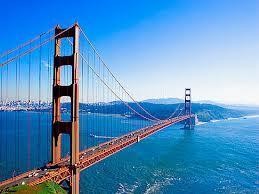
001-GOLDEN GATE BRIDGE-The Golden Gate Bridge is a suspension bridge spanning the Golden Gate strait, which is mile-wide and three-mile-long channel between San Francisco Bay and the Pacific Ocean. The bridge connects the San Francisco to Marin County. Construction of the Golden Gate Bridge started in 1933 and completed in 1937, at that time of its completion it was the world’s longest suspension bridge. The bridge is one of the most internationally recognized symbols of San Francisco. Today more than 1, 20,000 cars crosses the bridge each day. The total length of the bridge from abutment to abutment is 8,981ft or 2,737 m. The main span between the two enormous towers is 4,200 feet or 1,280 meters long (longest in the world-Akashi Kaikyō Bridge=1991mts), making the Golden Gate Bridge the world's largest suspension bridge. The two beautiful Art Deco towers are almost 820ft or 250 meters tall(tallest in the world-Millau Viaduct=343mts), of which more than 20 meters is below the sea level , these towers were the world's tallest on a suspension bridge until 1998 when bridges in Denmark and Japan were completed. The roads are six lanes and 90 feet (27m) wide is an amazing 220 feet or 67 meters above the water level. It is supported by enormous cables, anchored in hundreds of bars locked into concrete blocks with a pulling power of 25 million kg. The two cables have a total length of 2,332 meters and a diameter of 90 cm. There is a sidewalk on the Golden Gate Bridge, it's quite a challenge to cross the bridge. Not only is it almost 3km long, but it is a breath taking 67 meter (220ft) above sea level. Alternatively you can take one of the busses that connect San Francisco with Marin County. There is a bus stop right at the start of the bridge. The Golden Gate Bridge is located at the Presidio Park and can easily be reached by bus or car. The most pleasant way to reach the bridge however is by walking either from the Marina District to the east or from Baker Beach to the west of the bridge.
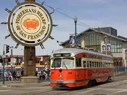
002-FISHERMAN'S WHARF-The Fisherman’s Wharf at San Francisco has always been a very lively area. From the late 19th century through to modern times, commercial fishermen gathered here to unload their catch of the day. Fisherman's Wharf is a northern waterfront area and popular tourist attraction. It is from Ghirardelli Square or Van Ness Avenue east to Pier 35 or Kearny Street. Fisherman's Wharf is best known for being the location of Pier 39, the Cannery Shopping Centre, Ghirardelli Square, a Ripley's Believe it or Not Museum, the Musée Mécanique (collection of old slot and coin operated machines), the Wax Museum at Fisherman's Wharf, the Aquarium of the Bay, and the San Francisco Maritime National Historical Park. Other attractions in Fisherman's Wharf area are the Hyde Street Pier, the USS Pampanito (a decommissioned World War II era submarine) and the Balclutha, (a 19th-century cargo ship). Nearby Pier 45 has a chapel in memory of the "Lost Fishermen" of San Francisco and Northern California. There is a sea lion colony next to Pier 39. Fisherman's Wharf plays host too many San Francisco events, including a world-class fireworks display for Fourth of July and some of the best views of the Fleet Week air shows. Some of the restaurants, including Fishermen's Grotto, Pompei's Grotto and Alioto's, go back for three generations of the same family ownership. Forbes Island restaurant at Pier 39 to stands that serve fresh seafood. Boats that offer bay cruises and/or journeys to Alcatraz Island also leave from the Fisherman's Wharf area as do various other land-based tours. Restrooms at Pier 39, at the Cannary and Anchorage shopping centres at Ghirardelli Square.


003-GOLDEN GATE PARK- Golden Gate Park, is a rectangular and large urban park consisting of 1,017 acres. It is over three miles long east to west, and about half a mile north to south. A hilly park with a varying landscape of lakes, meadows, ridges and winding roads. To convert the sand dunes into a forested parkland, innovative sand reclamation techniques were used and a dike was built to protect the park from the sea. With 13 million visitors annually. The Golden Gate Park is located between Haight Ashb-ury and the Pacific Ocean in downtown San Francisco. California State Highway 1 crosses the park north-to-south as Crossover Drive. Statues of historical figures are located throughout the park. The park is also popular for its sports facilities which include ten-nis, pétanque, golf, fly-fishing, biking, inline skating, archery, handball and horseback riding. Main Attractions-
i-Music Concourse Area-The Music Concourse is a sunken, oval-shaped open-air plaza . Its focal point is the Spreckels Temple of Music, also called the "Bandshell," where numerous music performances have been staged. It includes a number of statues of various historic figures, four fountains, and a regular grid array of heavily pollarded trees.
ii- De Young Museum- The De Young Museum is a fine arts museum that was opened in January 1921.De Young was San Francisco’s newspaper magnate. The Fine arts Museum, temporarily built for the expo, was so successful that it was decided to establish a permanent museum. The museum has a very diverse collection, including paintings from the Laurance Rockefeller collection.
iii- Academy of Sciences- The Academy of Sciences carries exhibits of reptiles and amphibians, astronomy, prehistoric life, various gems and minerals, earthquakes, and aquatic life. The California Academy of Sciences is the "largest Platinum building in the world, and also the world’s greenest museum". The Academy is a single structure but contains multiple venues, including the aquarium, the planetarium, the natural history museum and the 4-story rainforest. In addition, there's a 3D theatre, a lecture hall, a Naturalist Centre, two restaurants, an adjacent garden and aviary, a roof terrace, and an Academy store. Promoting a better relationship between humans and their natural surroundings, a vegetation-covered roof helps increase biodiversity. An open-air observation deck conveniently places guests in the thick of the “Living Roof.”


iv- Japanese Tea Garden-The 5 acres Japanese Tea Garden is the oldest Japanese garden in the USA. Following the success of the expo's Japanese village, a Japanese Tea Garden was constructed to display the Japanese lifestyle. The garden has the Drum Bridge and the tea house and additions included a pagoda and Zen garden.
V-Conservatory of Flowers-The Conservatory of Flowers is one of the world's largest conservatories. A Victorian-style greenhouse is modelled after the Palm house at the Kew Gardens in London. It was built between 1876 and 1883 and houses a collection of tropical plants and flowers.
vi- San Francisco Botanical Garden-Located in Golden Gate Park, San Francisco Botanical Garden boasts nearly 7,500 individual plants of varying kinds, including Mediterranean, mild temperate, and tropical cloud forest plants arranged in a variety of habitats. Visitors can also visit the horticultural delights of New Zealand, Chile, Eastern Australia or travel through a delightful collection of colourful rhododendron. There's also a lovely children's garden and a wildfowl pond for all to enjoy.
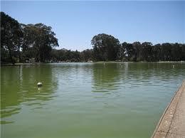


Viii -Spreckles Lake-An artificial reservoir behind a small earthen dam that lies on the north side of the Golden Gate Park. One can usually find both 'sail driven,' self-guided Yachts and radio-controlled model boats
xi- Kezar Stadium-Kezar Stadium was built between 1922 and 1925 in the southeast corner of the park. It hosted various athletic competitions.
x- Polo Fields-The Polo Fields once known as Golden Gate Park Stadium was opened in 1906 and originally envisioned as a 60,000 seat amphitheatre with a mile-long circumference.
xi- Windmill-In 1902, the parks commission authorized construction of two windmills to pump subterranean water to supply the park. The first, on the north side of the park facing the Pacific Ocean, was completed in 1903 and became known first as the North Windmill.
xii- Beach Chalet-The two-story Beach Chalet faces the Great Highway and Ocean Beach at the far western end of the park. It was opened in 1925 in Spanish colonial revival style as a city-run restaurant and included changing rooms for beach visitors.
xii- Beach Chalet-The two-story Beach Chalet faces the Great Highway and Ocean Beach at the far western end of the park. It was opened in 1925 in Spanish colonial revival style as a city-run restaurant and included changing rooms for beach visitors.


004-CABLE CAR SYSTEM- This is an icon of San Francisco. Of the twenty-three lines established between 1873 and 1890, only three remain, two routes from downtown near Union Square to Fisherman's Wharf, and a third route along California Street. The vast majority of their riders are the 7 million annual passengers are tourists. They are among the most significant tourist attractions in the city, along with Alcatraz Island, the Golden Gate Bridge, and Fisherman's Wharf. In fact the cars don't even have any drive mechanism themselves .The cable cars are pulled by a cable running below the street, held by a grip that extends from the car through a slit in the street surface, between the rails and driven by a 510 horsepower electric motor located in the central power house. The Cable Car Museum is housed in the Cable Car Barn which is also an active depot for the system. Here you can see the mechanism of engines, cables, gears and brakes that pull the cable cars. The cable cars are not to be confused with San Francisco's heritage streetcars, which operate on Market Street and the Embarcadero. The cable car lines operate 365 days a year from 6:30 a.m. until just after midnight. Cable cars are scheduled to operate every 6-15 minutes, depending on the time of day. Cable car tickets and one-day Cable Car Passes are sold on board cable cars by the conductors. Conductors can make change for up to $20. No transfers are accepted or issued on cable car. August 23, 2013, riding a cable car costs $6 for a single ride, except for senior’s citizens, riding before 7am or after 9pm when the senior fare is $3. $6 Cable Car Souvenir Tickets are sold in advance and include a San Francisco souvenir as well as a single ride. The payment is only for one ride if transfer from one ride to other will have to pay again. If planned more than two ride then take one day pass.
i-The Powell-Hyde (Line 60)-This line runs north and steeply uphill from a terminal at Powell & Market Streets. Powell-Hyde goes from Market and Powell to Union Square, Cable Car Barn Museum, Nob Hill, and Russian Hill, Lombard Street ends at Ghiradelli Square near Aquatic Park.The Hyde and Beach Terminal, which is adjacent to the waterfront at the San Francisco Maritime Museum. Manually-powered turntables turn the cable cars around at the two ends. This line is used greatly by tourists and often has long queues. ii-The Powell-Mason (Line 59)-This line and starts at Powell & Market Street and shares the tracks of the Powell-Hyde line as far as Mason Street. Powell-Mason Goes from Market and Powell to Bay and Taylor Street through North Beach and ends near Fisherman’s Warf. As with the Powell-Hyde, there are manually-powered turntables at each end to reverse the cars. This line is also used greatly by tourists, but also some commuters.
iii-The California Street (Line 61)-This line runs east and west on California Street from a terminal at California and Market Streets, close to the famed Embarcadero to Van Ness Avenue. California Street -Drumm to Van Ness on California Street through the Financial district, China Town, Nob Hill. This line is used to a greater extent by commuters, with majority of passengers on weekdays being commuters.
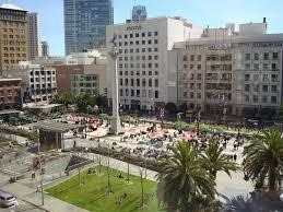
005-UNION SQUARE- Union Square is a 2.6-acre plaza bordered by Geary, Powell, Post and Stockton Streets. The "Union Square" is the central shopping, hotel, and theatre district that surrounds the plaza for several blocks. Union Square got its name from the pro-Union rallies held there on the eve of the Civil War.Today, this one-block plaza and surrounding area is one of the largest collections of department stores, upscale boutiques, gift shops, art galleries, and beauty salons in the United States, making Union Square a major tourist destination, cosmopolitan gathering place in downtown, and one of the world's premier shopping districts. Union Square retains its role as the ceremonial "heart" of San Francisco, serving as the site of many public concerts & events, art shows, protests, private parties and events, winter ice rink and the annual Christmas tree. The only hotel located on Union Square is the Westin St. Francis Hotel which is celebrated for its historic Magneta Grandfather Clock. The Tiffany Building is an 11 story, building at Union Square. It boasts six major department stores: Macy's, Bloomingdale's, Barneys New York, Nordstrom, Saks Fifth Avenue, and Neiman Marcus. Two cable car lines (Powell-Hyde and Powell-Mason) serve Union Square on Powell Street. Union Square is served by numerous trolley and bus lines and the F Market heritage streetcar. At the centre of Union Square stands a tall Corinthian column topped with a statue of Victoria, goddess of victory. The monument also known as the Dewey Monument, commemorates the victory of Admiral George Dewey in 1898 at Manila Bay during the Spanish - American war.
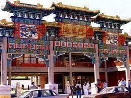
006-CHINA TOWN- San Francisco's Chinatown is not only the oldest but also the most famous and largest Chinatown in the US, it is roughly 1 mile long and 1.35 mile wide. San Francisco's Chinatown was first established in the mid19th century, attracting immigrants mostly from China's Guangdong Province. Most of these individuals had jobs with the Central Pacific Railroad. They soon established their own town within the city. Chinatown remains a major tourist attraction to this day. The most photographed structure in Chinatown is undoubtedly the large Chinatown Gateway, also known as the Dragon Gate. The entrance gate to Chinatown is also located at Grant Street. The gate is adorned with sculptures of fish and dragons and is flanked by two large lion statues. The gate has three passageways. The large, central one is meant for dignitaries while the two smaller passageways are meant for the common people. Most of the shops are located around Grant Street, the central axis of Chinatown's tourist area. Here all lampposts are ornamented with colourful Chinese motifs. Another attraction for visitors are the many temples in Chinatown. Most are situated at the upper level of row houses, so they are closer to heaven. In Waverly Place - known as 'the street of painted balconies' - are not less than three temples, among them the well-known Tin How Temple. This temple was founded in 1852 and is the oldest in the United States. Besides the temples there are many other interesting buildings in Chinatown such as the Old St. Mary's Church, a catholic church from 1854 and San Francisco's oldest cathedral. There's also the Bank of Canton a 1909 structure that was built as a telephone exchange - its operators spoke a range of different Chinese dialects and the historic Sing Chong Building. Chinatown is "the most densely populated urban area west of Manhattan," with 15,000 residents living in 20 square blocks.
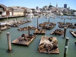
007-PIER 39- Pier 39 is a 45 acre complex located at the waterfront just a few blocks from famous Fisherman's Wharf. The views from the pier are wonderful. Pier 39 was originally built in 1905 as a cargo pier. Pier 39 is a shopping centre and popular tourist attraction built on a pier. At Pier 39, there are shops, restaurants, a video arcade, street performances, an interpretive centre for the Marine Mammal Center, the Aquarium of the Bay, virtual 3D rides, and views of California sea lions hauled out on docks on Pier 39's marina. There are also some other stores such as an NFL Shop Pier 39, San Francisco and a store that sells anything for left-handed people. The marina is also home to the floating Forbes Island restaurant. A large number of these restaurants specialize in seafood. There are also plenty of food stands and fast food eateries including ice cream shops and a chocolate shop. A two-story carousel is one of the pier's more dominant features, although it is not directly visible from the street and sits towards the end of the pier. The family-oriented entertainment and presence of marine mammals make this a popular tourist location for families with kids, the kids can go to Carousel, handcrafted in Italy, jump on the bungee trampoline, or explore the mirror maze. The pier is located at the edge of the Fisherman's Wharf district and is close to North Beach, Chinatown, and the Embarcadero. The area is easily accessible via the historic F Market streetcars. From the pier one can see Angel Island, Alcatraz, the Golden Gate Bridge, and the Bay Bridge. Blue & Gold Fleet's bay cruises leave from Pier 39. For some free fun, take a moment to watch Pier 39's famous sea lions frolic in the surf. The first sea lions arrived here in 1990 shortly after the Loma Prieta earthquake in 1989. Their numbers quickly grew into the hundreds. The large colony stays here during wintertime and migrates south for the breeding season, although a small number stays here year-round. The Pier 39 provides a safer place to Sea Lions from Orka and Great White Shark as they do not enter the bay. It is a natural San Francisco sightseeing attraction visited by people each year.(Cable Car-Powell-Hyde Line)

008-LOMBARD STREET- Lombard Street is a long road situated between Embarcadero and the Presidio Park, where it becomes a main artery channelling traffic to the Golden Gate Bridge. The street is famous for a small section near the top of Russian Hill, between Hyde and Leavenworth Streets. Here the hill is steep (27°) that it would be too dangerous for most vehicles, so between 1922 and 1923 this part of Lombard Street was transformed into a switchback with eight sharp turns. The crooked block is perhaps 600 feet long 412.5 feet straight-line, is one-way (downhill) and is paved with red bricks. The sign at the top recommends 5 mph. Cars can only drive downhill, east-bound towards Leavenworth Street. The sight of cars manoeuvring down the winding road has become a popular tourist attraction. Better take the Powel-Hyde cable car which stops at the top. From here you have a view down Lombard Street, but you can also see Fisherman's Wharf and Alcatraz. Walking down to Leavenworth Street, at the bottom of the crooked street, you get an even better view of Lombard Street, looking up towards all the cars slowly heading down. Even though Lombard Street is billed as the crookedest street in the world, it is not even the most crooked or steepest street in San Francisco. The steepest street is Filbert Street with a 31.5° slope while Vermont Avenue at 20th Street claims to be the most crooked. And Snake Alley in Burlington, Iowa, has even sharper turns.

009-COIT TOWER-The 210ft tall Coit Tower on top of Telegraph Hill is a monument dedicated to the San Francisco Firemen. The Coit Tower was built in 1933 with funds from Lillie Hitchcock Coit. She was an eccentric personality who was best known for her support of the local firemen. When she died, she left one third of her fortune for the beautification of the city. The result was the Coit Tower, which is both a memorial for Lillie Hitchcock Coit and for the San Francisco firemen. The interior of the cylindrical tower is embellished with a large number of murals, most of them depicting life in California during the Great Depression. At the top of the Coit tower is an observation platform with spectacular 360° views over San Francisco. The Coit Tower is built on top of the 285ft high Telegraph Hill, which is situated between Fisherman's Wharf and the Financial District. In 1850, a pole with movable arms on top of the hill was used as a signaling station. The wooden arms were adjusted to signal the incoming of ships. In 1853 it was replaced by an electric telegraph station, hence the hill's name. The Coit Tower can be reached by walking up the Greenwich steps or via the scenic Filbert Steps at Montgomery Street.
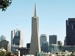
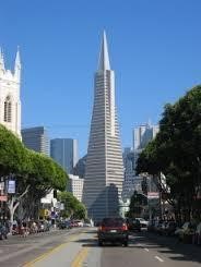
010-TRANSAMERICA PYRAMID-The Transamerica Pyramid is the tallest skyscraper in the San Francisco skyline at Financial District. The building was the headquarters of the Transamerica Corporation, but it is still depicted in the company's logo. It is at 853 feet, on completion in 1972 it was the eighth tallest building in the world. It has 48 floors with a 210ft high spire on top, covered with aluminium panels. The building owes its sparkling white colour to the layer of crushed quartz that covers the rest of the building.

011-555 CALIFORNIA STREET- 555 California Street, formerly Bank of America Centre, is a 52-story 779 feet (237 m) skyscraper in San Francisco. It is the second tallest building in the city and a focal point of the Financial District. Completed in 1969, the tower was the world headquarters of Bank of America until the 1998 merger with Nations Bank.
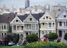
012-ALAMO SQUARE-The picturesque Victorian row houses at Alamo Square are among the most photographed buildings in San Francisco. The buildings give a good idea of what San Francisco looked like at the end of the 19th century. Alamo Square is a 13 acres area atop Alamo Hill. This area is high above the city and windiest part of the city. "Painted ladies" is a term in American architecture used for Victorian and Edwardian houses and buildings painted in three or more colours that enhance their architectural details. One of the best-known groups of "Painted Ladies" is the row of Victorian houses at 710–720 Steiner Street, across from Alamo Square Park. For other visitors, however, they are simply recognized as exquisite homes painted in colourful hues, incredibly well-preserved and a joy to view. The brightly coloured houses give a good idea of the architectural style that was predominant in San Francisco during the second half of the 19th century.

013-PALACE OF FINE ARTS-The Palace of Fine Arts in the Marina District of San Francisco, California, is a monumental structure originally constructed for the 1915 Panama-Pacific Exposition in order to exhibit works of art presented there. One of only a few surviving structures from the Exposition, it is the only one still situated on its original site. The lagoon surrounding the building served to reflect the structure and was reminiscent of similar settings common in Europe. In 1969, a science museum was opened there and by the 70s, the north and south colonnade rose again and the gallery became the permanent home of the Palace of Fine Arts Theatre, a 1,000 seat performing arts theatre that hosts a variety of concerts and events.

014-SAN FRANCISCO MARITIME NATIONAL HISTORIC PARK, HYDE STREET PIER-Hyde Street Pier is situated in the Fisherman's Wharf area. The pier and the historic vessels berthed there are all an important part of Pacific Coast maritime history. The pier attracts hundreds of thousands of visitors each year and a Hyde Street Pier. At the Visitor Centre, guests can also arrange for guided tours. Once you leave the Visitor Centre, you can begin to explore the vessels, which include: Balclutha(1886),CA Thayer(1895),Eureka(1890),Alma(1891),Hercules(1907).

015-FERRY BUILDING-This is a city landmark for more than 100 years, San Francisco's Ferry Building was once the arrival point for all ferry traffic to the city. Today the historic building houses a food market. Opened in 1898 on the site of an old wooden ferry house, the Ferry Building was a hub of San Francisco activity. The Ferry Building Marketplace is located along the Embarcadero at the foot of Market Street. It is the centre of a transit hub that connects all of San Francisco's neighbourhoods and the surrounding bay communities. Built in 1898, the Ferry Building and its 240-foot tall clock tower is the iconic landmark of the San Francisco waterfront. The dramatic heart of the building is a three-story tall, sky lit hall, known as the Nave. It runs the entire 660-foot length of the building. The ground floor of the Ferry Building is devoted to a 65,000 square foot public food market showcasing the very best of the Bay Area's world-renowned food community. The second and third floors of the building house 175,000 square feet of office space.

016-AQURIUM OF BAY- This is located next to Pier 39 on the Embarcadero just a short walk from Fisherman's Warf .The Aquarium is dedicated to the conservation of San Francisco Bay's unique ecosystem and diverse population of aquatic marine life. The aquarium hosts roughly 6,00,000 visitors each years .The facility provide 300 feet acrylic tunnel holding 7,00,000 gallons of filtered bay salt water. The aquarium houses sharks, bat rays and skates. The aquarium has three different environment- i-Discover the Bay ii- Under the Bay iii- Touch the Bay. (Cable Car-Powell-Hyde Line)

017-CLIFF HOUSE- The cliff house is a landmark since 1863. The Cliff House is now part of the Golden Gate National Recreation Area. Two restaurants offer great views of the ocean. There is a gift shop in the building, and the historic camera obscura is on a deck overlooking the ocean.

018- F LINE -HISTORIC STREET CAR-This runs from Fishersman's Warf south along the waterfront Embarcadero to Ferry Building at the foot of Market Street, then on the surface to the Castro district. The F-Market & Wharves historic streetcar line runs six miles each way between Fisherman’s Wharf and the Castro District. Along the way, you’ll see sights both historic and modern. The F-line is open 365 days a year from 6:00 a.m. until after midnight. Streetcars are scheduled to run at least every 15 minutes and as frequently as every six minutes during daylight hours. The fare is $2.00.
019- FINANCIAL DISTRICT- The Financial District is the main central business district. It is home to the city's largest concentration of corporate headquarters, law firms, insurance companies, real estate firms, banks, savings and loans, and other financial institutions. All six San Francisco Fortune 500 companies McKesson, Wells Fargo, PG&E Corporation, Gap, URS Corporation, and Charles Schwab—are located in the district.
The area is marked by the cluster of high-rise towers in the triangular area east of Grant Avenue, south of Washington Street, west of the Embarcadero that rings the waterfront, and north of Market Street. The city's tallest buildings, including 555 California Street and the Transamerica Pyramid, and many other tall buildings, such as 101 California Street and 345 California Street are located there. Montgomery Street (sometimes called "Wall Street of the West") is the traditional heart of the district.
The area is marked by the cluster of high-rise towers in the triangular area east of Grant Avenue, south of Washington Street, west of the Embarcadero that rings the waterfront, and north of Market Street. The city's tallest buildings, including 555 California Street and the Transamerica Pyramid, and many other tall buildings, such as 101 California Street and 345 California Street are located there. Montgomery Street (sometimes called "Wall Street of the West") is the traditional heart of the district.

020-CIVIC CENTER- San Francisco's Civic Centre area, which encompasses a number of excellent classical-style buildings and well as some modern structures, is a real treat for lovers of architecture. Civic Centre is laid out around a large symmetrical square, the Civic Centre Plaza. Some of the most important buildings in the area are located on the west side of Civic Centre, where you'll find the State Building, Veterans Building, Opera House and Symphony Hall.

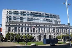
i-City Hall- The city hall of San Francisco is one of the country's most magnificent Beaux-Arts buildings. The present City Hall in San Francisco was built in 1915 and replaced a previous building that was destroyed in the 1906 earthquake. City Hall is massive at 390 feet long (119m) and about 273 feet wide (83m). It covers about 500,000 square feet (46.000 m2) or nearly two city blocks. Its dome is one of the largest in the world. Its central dome is even taller than that of the United States Capitol in Washington, D.C. The Dôme des Invalides in Paris served as the inspiration for the huge dome. The exterior is faced with granite and the inside uses various marbles and the city hall's interior features beautiful stuccoed walls and ceilings, marble floors and a monumental marble staircase flanked by elegant lanterns.

ii- War Memorial Opera House-This beautiful 3,146-seat opera house has been home to the San Francisco Opera Company since 1932. Considered to be one of the last Beaux-Arts buildings constructed in America, the opera house boasts beautiful Roman Doric columns and arch-headed windows. The building was designed by Arthur Brown and G. Albert Lansburgh. Inside, the building is quite ornate, featuring lovely coffered ceilings, beautiful staircases, massive chandeliers, and lots of gilded sculpture. The building suffered severe damage in the Loma Prieta earthquake in 1989 and required extensive renovation.

iii- Louise M. Davies Symphony Hall-One of the newer buildings in the Civic Centre complex, Symphony Hall was built in 1980 and gave a permanent home to the San Francisco Symphony Orchestra. The concert venue seats about 2,700 patrons and is also home to a wonderful 5-manual pipe organ. Sculpture lovers should look for Henry Moore's "Large Four Piece Reclining Figure" (1973) outside the theatre.
iv- Earl Warren (California State) Building-This attractive building is on California's National Register of Historic Places. Named for the former Chief Justice of the U.S. and designed in the American Renaissance style, the original structure was six stories high and 372 feet long (113m). Two wings were added in the 1930s. The facade is faced in grey California granite and terra cotta-simulating granite. The three-story base is topped by two stories of alternating arched and pediment windows. Italian Renaissance ornaments also grace the facade and three monumental arches can be found at the McAllister Street entrance.
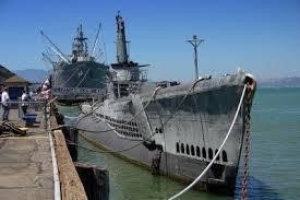
021- USS PAMPANITO- The USS Pampanito is a historic submarine that saw a lot of action in the Second World War. The submarine is now permanently docked at Pier 45. The submarine is 312 feet long and has maximum diving depth of 400 feet. It also boasted much more sophisticated gear for locating targets and carried new electronic torpedoes. Visitors can get on board the ship and walk through its cramped spaces. Opened to the public in 1982. Visitors who board this fascinating vessel have the opportunity to truly experience what life was like aboard this crowded submarine. Upon entering, guests can visit the main deck as well as the crew's mess quarters, the engine and motor rooms, the radio and control rooms, the pump room, the forward battery compartment, and the forward torpedo room. Inside you realize just how cramped it must have been for the submarine's 10 officers and 70 seamen.
DAY TOURS FROM SAN FRANCISCO –
TOUR-1-Yosemite National Park and Giant Sequoias Trip- The tour duration is 14 hours. The Giant Sequoias are best visited between May and October. During the rest of the year, snow and ice conditions may prevent access to roads and trails. TOUR-2-Monterey, Carmel and 17-Mile Drive Day Trip from San Francisco- The tour duration is 11 hours. Full-day trip from San Francisco to Monterey and Carmel and Coastal 17-Mile Drive along Highway 1. TOUR-3-San Francisco: Muir Woods and Wine Country Tour – The duration of tour is 9 hours. Muir Woods, where you'll explore the redwood sequoia forest, then visit wine country for some superb wine tasting at Napa and Sonoma's boutique wineries.


|
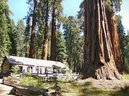
001-REDWOOD FOREST- Redwood trees are the Americas greatest and most natural treasures are the tallest trees on earth, the Coast Redwoods. The Redwood grows in a very narrow strip along the coast of California from Oregon (south-western corner) to 150 miles south of San Francisco(in the Soda Springs).Therefore the length is about 500 miles long and 20 miles wide. It needs summer fog, moderate temperature and plenty of winter rainfall. It’s a rapidly growing tree .Average matured tree are from 200 feet to 240 feet high and 10 to 15 feet diameter. Exceptional trees reach a height of 350 feet and diameter of 20 feet. Redwood National Park & State Parks is home to these trees. Redwood Park and State Park is situated along the coast of northern California. Comprised of four units i-Redwood National Park ii-Del Norte Coast, iii-Jedediah Smith and iv-Prairie Creek Redwoods State Parks, these four parks protects 45% of all reaming coast redwood forest. This area is near Cresent City(355miles north of SFO). The trees are up to 367 feet tall and 22 feet at base of the trunk. Sequoia are the tallest and one of the most massive tree species on Earth .In 1968 Redwood National Park was created to conserve the forest and by this time nearly 90% of the original redwood trees had been logged. The tallest tree in the park was Hyperion at 379.1 feet tall then Helios at 376.3 feet tall and Lcarus at 371.2 feet tall. Mature Coast Redwoods live an average of 500-700 years and some of them to be 2,000 years old, making them as the longest living organisms on the earth. Another large tree commonly found in the forest is the Coast Douglas-fir up to 300 feet. The relatives are found at King Canyon, Sequoia and Yosemite National Park. The root system of the trees is shallow and may not reach to 6-12 feet deeper, but they typically spread 50-80 feet around.They grow close together and remains upright for the millenniums by intermingling root system. The name of the tree “REDWOOD” is derived from the colour of heartwood than colour of bark. The bark is 1 feet thick and protects against fire, insects, fungus, diseases, there is no insect which can kill a redwood tree. The wood of the tree is hard but brittle so when cut the tree the fall of the tree are cushioned to avoid shattering. One of the keys to the survival of the redwood is its regenerative abilities. Saplings from the blur are grown. The oldest trees are necessarily the tallest, there is no correlation between age and height. Temperature range from 4 to 150 C year round along Redwood Coastline .The redwood trees does not like freezing. Redwoods rely on the fog that envelopes the coast in the summer and supplies up to 25% of the water. The redwood likes the mild, moist climate of coastal northwest. It’s the area with an average of 70” of rain falls each year. A redwood tree transpires 200-500 gallons water each day. Humboldt Redwoods State Park (230miles north of SFO) is a state park of California, United States, the world's largest remaining contiguous old-growth forest of coast redwoods. Over 100 of the 137 known trees over 350 feet tall—all coast redwoods—occur in Humboldt Redwoods State Park. It is home to the 4th-tallest measured living redwood, the Stratosphere Giant, which was measured at 112.94 meters (370.5 feet) in 2004. There are three "Drive-Through" Trees located on the North Coast. All are privately owned and a fee is charged to drive through. The closest one to Humboldt Redwoods State Park is the Shrine Drive-Thru Tree in Myers Flat, four miles south of the park visitor's center. Klamath Tour Thru Tree- This tree is just 19 miles south of Crescent City and can be found just off of HWY 101 at the Terwer Valley Road exit before the bridge over the Klamath River in Klamath.
|


|
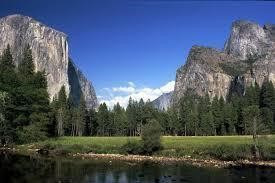
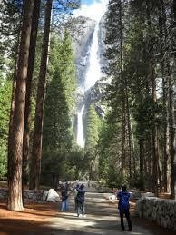
002-YOSEMITE NATIONAL PARK -Yosemite National Park covers an area of 3080.74sq km and over 37 lacs people visit Yosemite each year. It has elevation range from 2127 feet to 13,114 feet. Most tourists spent their time in the Yosemite Valley which is only 7sq kms. It is popular park for granite cliffs, waterfalls, clear streams, Giant Sequoia groves and biological diversity. Nearest City is Mariposa, California. Yosemite National park is located in the central Sierra Nevada of California and it takes 4 hours to drive to the park from San Francisco (195miles) and 6 hours from Los Angeles (315miles). It has thousands of lakes, 1600 miles of stream, 800 miles of hiking trails, 350 miles of roads. Yosemite Falls are the famous waterfalls and highest in the world at 2425 feet. The Wawona Tree, also known as the Tunnel Tree, was a famous giant sequoia that stood in the Mariposa Grove. The Wawona Tree fell in 1969 under a heavy load of snow. It was estimated to have been 2,300 years old. The park has three groves of ancient Giant Sequoia trees; the Mariposa Grove (200 trees), the Tuolumne Grove (25 trees), and the Merced Grove (20 trees). Two Wild & Scenic Rivers, the Tuolumne and Merced rivers, begin in the park and flow west to the Central Valley. Yosemite Valley, approximately 3,000 feet deep and less than a mile wide, is known for its incredible rock formations, created from plutonic rock that cooled far below the earth’s surface, this is where most visitors arrives and stay. Some of the most famous Yosemite cliffs, mountains & rock formations are (i) Half Dome (8,842 ft.) among the most recognized natural features in Yosemite, its western face is a sheer cliff of Plutonic granite - the youngest in Yosemite. (ii) Sentinel Rock (7,038 ft.) on the south side of Yosemite Valley, named for its likeness to a watchtower. (iii) El Capitan (7,569 ft.) towers 3,593 ft. above the valley floor. Rock climbers from around the world come to this Yosemite Mountain to challenge their abilities on its granite face giving visitors an excellent opportunity to view this unique sport. The Tunnel View is the first view of the Valley and is a most photographed point, this view gives a view of El Captan (7569ft) on left, and Bridalveil Fall on right and Half Dome in the Centre. Yosemite, waterfalls draw visitors from around the globe year after year. Because many of Yosemite’s waterfalls are fed by snowmelt, the amount of water rushing over each waterfall can vary widely throughout the year. The crown jewel of Yosemite's waterfalls, Yosemite Falls is one of the tallest in North America and fifth highest in the world. Actually made up of three separate falls, it has a total drop of 2,425 feet. Yosemite Falls is also known for its moon bow display in spring and a "snow cone" that forms at the base of the upper fall in winter. Fed by snow melt, the peak runoff is typically in May or June, and the roar of the falls can be heard in many parts of the eastern portion of Yosemite Valley. Once all of the snow in the high country has melted away, Yosemite Falls becomes only a trickle and is often dry by August. Prominent as you enter Yosemite Valley, it's hard not to notice the beauty of Bridalveil Fall. Bridalveil Fall flows all year with peak flow in May. The Lyell Glaciers, 0.25sq miles is the largest glaciers in Yosemite National Park. Transportation inside the Park- A-Shuttle-The Yosemite Area Regional Transportation System (YART) offers transportation into the valley from towns east to west including -Mercer - Mariposa-El Portal-Lee Lining -Mammonth Lakes. B- The Free Hybrid Shuttle is an environmentally friendly and easy way to explore the park. There are also many transit options to experience the park beyond Yosemite Valley. C-Yosemite Tours & Guided Activities-The better way to discover the Park's incredible scenery and hidden secrets than by professional Yosemite tour guides introduce you to the wonders of the land through the Yosemite Park tours they are-Valley Floor Tour ,Grand Tour, Tuolumne Meadows Tour, Glacier Point Tour, Big Trees Tram Tour, Moonlight Tour and Stargazing Tour. |


003-BIG SUR- Big Sur is a 90-mile stretch of rugged and awesome beautiful coastline between Carmel (which is 150 miles south of San Francisco) and San Simeon (near Hearst Castle and 300 miles north of Los Angeles).Along the California Highway 1(also known as Pacific Coast Highway) there is a majestic Santa Lucia Mountains and on the other side is the rocky Pacific Coast. Big Sur's Cone Peak is the highest coastal mountain, ascending nearly a mile (5,155 feet) above sea level, only three miles from the ocean .In 1937, the present highway was completed after eighteen years of construction with the aid of convict labours. The highway is the first scenic highway of California .Big Sur has attained a worldwide reputation of its spectacular beauty. The scenic qualities and natural grandeur of the coast and meeting of land and sea are the greatest attractions. Hiking, backpacking and scenic driving are major
Activities. After World War II ended, tourism and travel boomed along the coast. When Hearst Castle opened in 1958, a huge number of tourists also flowed through Big Sur. The highway winds along the western flank of the mountains mostly within sight of the Pacific Ocean, varying from near sea level up to a thousand-foot sheer drop to the water. Because gazing at the views while driving is inadvisable, the highway features many strategically placed vista points allowing motorists to stop and admire the landscape. There are a few small, scenic beaches that are popular for walking, but usually unsuitable for swimming because of unpredictable currents. There are nine state parks along the Big Sur area. When driving on Highway 1 through Big Sur be sure to stop at the many turnouts and vista points to see the beauty of the area. Big Sur Village is a mile-long village containing gas stations, roadside markets, lodges and restaurants and is 24 miles south of Carmel. There is a biggest Redwood Tree at Pfeiffer Big Sur State Park.
Activities. After World War II ended, tourism and travel boomed along the coast. When Hearst Castle opened in 1958, a huge number of tourists also flowed through Big Sur. The highway winds along the western flank of the mountains mostly within sight of the Pacific Ocean, varying from near sea level up to a thousand-foot sheer drop to the water. Because gazing at the views while driving is inadvisable, the highway features many strategically placed vista points allowing motorists to stop and admire the landscape. There are a few small, scenic beaches that are popular for walking, but usually unsuitable for swimming because of unpredictable currents. There are nine state parks along the Big Sur area. When driving on Highway 1 through Big Sur be sure to stop at the many turnouts and vista points to see the beauty of the area. Big Sur Village is a mile-long village containing gas stations, roadside markets, lodges and restaurants and is 24 miles south of Carmel. There is a biggest Redwood Tree at Pfeiffer Big Sur State Park.

i-POINT SUR LIGHT STATION-The Light Station is located on the Big Sur coast 19 miles south of Carmel(135 miles from San Francisco) and 361 feet high above MSL. The Light House was constructed during 1887-1889, and was the area of several ships disasters. It is 40 feet tall and still in operation. Walking tours of Point Sur Lighthouse are held year-round on Wednesdays and weekends.

ii-BIXBY CREEK BRIDGE-This bridge is located at 13 miles south of Carmel (190 miles from San Francisco).It is a concrete arch bridge with 320 feet longest span , built in 1933.Its total length is 714 feet and 280 feet high. The bridge is “one of the most photographed on the West Coast”.
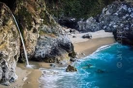
iii-MC WAY FALLS-McWay Falls is an 80-foot waterfall located in Julia Pfeiffer Burns State Park. The source of the waterfall is McWay Creek and is one of the few waterfalls that empties directly into the ocean.

004-HIGHWAY ONE- Highway One is the best-known scenic drive in Monterey County, and one of the top scenic drives in the world. It's been named one of the best scenic drives in the U.S. At Monterey County's northern border, you'll see the flat wetlands of Elkhorn Slough and the working fishing port of Moss Landing. Drive even further south and you'll see the towering cliffs, beautiful redwoods and stunning bridges of Big Sur. Using the Monterey Peninsula as your home base, it's only a half-hour north on Highway One to Moss Landing, 45 minutes to the village of Big Sur, and about 90 minutes to the southernmost part of the Big Sur region. This drive is also a piece of one of America's epic road trips - Highway One from San Francisco to Los Angeles.

005-MOSS LANDING PUBLIC DOCK- Moss Landing built a public dock in 2007 to be used by visitors, and it immediately got more use than expected from a surprise source- sea lions. Harbour officials say that over 400 sea lions use the public dock as their hang-out space. From the walkway above the dock, you can get a close-up view of their antics as they sun themselves, crawl over each other, and dip into the water. To find the dock, head to Moss Landing on Route 1. On the west side of Route 1, next to a large parking lot, you'll see a building with a teal roof, by the side of the inlet into Elkhorn Slough. This building is perched right above the sea lion dock


006-AT MONTEREY - WHALES, SEA OTTERS, SEALS & SEA LIONS & A MARINE SAFARI -California is one of the only places in the world where visitors can see whales year-round, and there's no better place for whale watching than Monterey. While in many areas whale watchers have to go far from shore to see a whale, along the Monterey coast whales can sometimes be seen offshore with the naked eye. The Monterey Submarine Canyon, the ocean's answer to the Grand Canyon, provides a perfect habitat for many whale species, allowing them to come close to shore to feed. As spring progresses and the days grow longer, the great migration of grey whales heading south from the Bering Sea to the calving lagoons off Mexico's Baja Peninsula draws to a close. During the season's peak (roughly December through March-April), as many as 7,000 grey whales pass south through the offshore waters of the Monterey Bay National Marine Sanctuary. This abundance of marine life attracts year-round whale watching cruises that depart from Monterey and Moss Landing in Monterey County. The Monterey Bay National Marine Sanctuary is the home to 27 species of marine mammals, 100+ species of marine birds, 345 species of fish and the leatherback turtle. Whale watching in Monterey Bay is the marine equivalent of going on a safari in Africa. In addition to the whales that migrate seasonally through the area, such as humpbacks, blue whales and grey whales, many other whale species are visible throughout the year. It's not unusual for whale watchers to spot a fin or minke whale. The rarely observed beaked whale, which dives for up to an hour at a time, has been known to make a cameo appearance, as has the occasional sperm whale. Whales aren't the only marine life visitors will spot in Monterey Bay. Thousands of Pacific white-sided dolphins, Risso's dolphins and Dall's frolic in the bay almost year-round. "Seeing several thousand dolphins is not unusual". "A lot of people would rather see dolphins than whales because dolphins are very active and will follow the boat." By law, boats are required to stay 100 yards away from whales. "What's really unique to Monterey Bay, is the killer whales hunting the grey whales." Gary whales, normally stick to shallow waters during their migration from mid-December to March-April. However, in order to cross the Monterey Canyon, the greys must venture into deeper water, where killer whales lurk, waiting to make a grey their next meal. From April through November, humpback whales and blue whales come to Monterey Bay to hunt a smaller prey - anchovies and krill. Humpbacks will often spend several days feeding in the same spot, giving whale watchers a predictable location to find them. The unpredictability, however, means that visitors can go out on a whale watch every day of the week and see something completely different - and many do. Sea otters delight all with their playful antics and can be seen at Municipal and Fisherman's Wharf, Cannery Row, the Breakwater, Lovers Point, Otter Point, Point Piños, Point Joe, Bird and Seal Rocks, Cypress Point, Pescadero Point, Carmel Point, and Point Lobos. Harbor seals, sea lions and elephant seals are fascinating residents of the Central Coast. They often bask-and bark!-on local beaches and rocks A-WHALE WATCHING TOURS-The tour depart daily. During our 2 1/2 to 3 hour trips and view the diverse inhabitants of the Monterey Bay. The Princess Monterey departs at 9am and 12:30pm and The Greatland departs at 10am and 1:30pm. Trip times vary by season so check out our calendar for the current schedule. The ticket is about $45.Here, you’ll have the chance to observe marine mammals such as the Gray Whale, Humpback Whale, Blue Whale, Fin Whale, Minke Whale, Beaked Whales, Orca (Killer Whale), Bottlenose Dolphin, Northern Right Whale Dolphin, Pacific White-sided Dolphin, Risso’s Dolphin, Harbor Porpoise, Dall’s Porpoise, California Sea Lion, Pacific Harbor Seal, and Southern Sea Otter. You’ll also have the opportunity to view seabirds such as Loons, Grebes, Black-footed Albatross, Shearwaters Pelicans, Cormorants, Phalaropes, Jaegers, Gulls, Terns, and Alcids. And don’t forget about sharks, the Ocean Sun Fish, jellyfishes, and even the Leatherback Sea Turtle!
a-California Grey Whales (December through April)-Traveling from the icy waters of the Bering and Chuckchi Seas, to the majestic lagoons of Baja California, Mexico, the grey whales have followed the same migratory route along the west coast of North America for thousands of years. These whales generally travel a few short miles from the coast, making the Monterey harbour an ideal departure point for intersecting what is known as the “Grey Whale Migration Highway”. b-Summer Whales (April through November)-In the summer months as Monterey Bay becomes the feeding grounds for multiple whale and dolphin species. Journeying from their warm-water breeding grounds, various whales travel to the Monterey Bay to indulge in the rich food sources available. This is the opportunity to see humpback whales, fin whales, minke whales, orcas (killer whales), and the mighty blue whale (the largest animal to inhabit the earth). In addition to these large whales, Monterey Bay is frequented by porpoises and large pods of Risso’s dolphins, northern right whale dolphins, and Pacific white.

|
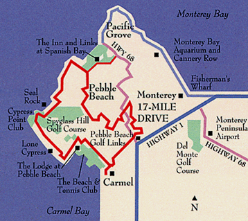
007-17-MILE DRIVE -The 17-Mile Drive winds through a forested area and along the oceanfront, passing three golf courses, two luxury hotels and the famed Lone Cypress tree. The drive from the Highway 1 Gate to the Carmel Gate is approximately 17 miles. 17-Mile Drive is a scenic road through Pebble Beach and Pacific Grove on the Monterey Peninsula. The majority of 17-Mile Drive is owned and operated by the Pebble Beach Corporation and non-residents have to pay a toll to use the road. 17-Mile Drive was one of Monterey County's top scenic drives. It began as a carriage road for guests at Monterey's Hotel del Monte in the early 1880s, and since then has been lauded for its magnificent scenery. The 17-Mile Drive is entered through four main gates. i-Highway 1 at Highway 68: This is the most convenient 17-Mile Drive entrance if you're coming from Monterey or are already on Highway 1
ii-Pacific Grove Gate: Get there from Sunset Drive. iii-Carmel: The toll booth is on San Antonio Ave. The main scenic points along the 17-mile drive are- a-THE INN & LINKS AT SPANISH BAY- It's called Spanish Bay to honour explorer Don Gaspar de Portola, who camped here with his ship's crew in 1769 while exploring the coastline and trying to find the Monterey Bay. Spanish Bay is the first stop that many visitors make along the 17-Mile Drive, with a big parking lot and a pretty beach. |
b-POINT JOE- Ships that have wrecked here include the iron-hulled St. Paul which crashed on a foggy night in 1896, then hung onto the rocks for 3 months before sinking - and the steamer Celia who got lost in the fog and wrecked in 1906. Both crews and the St. Paul's livestock cargo were rescued, but the Celia's load of lumber was lost. c-BIRD ROCK- Here see Brandt's cormorants, pelicans and California sea lions sharing the rock - and a harbour seal or two hanging out near the water line.
d-FANSHELL OVERLOOK AND CYPRESS POINT LOOKOUT- These are favoured spots for mother harbour seals to deliver their babies. During pupping season (April 1 to June 1), Fanshell Overlook and Cypress Point are both closed to give the little ones.
e- MONTEREY CYPRESS LOOKOUT POINT- This is a vista point for Monterey Cypress tree and seen from distance, which are in the 5300-acre Del Monte Forest. The Monterey Cypress is a rare tree that grows only here and at Point Lobos just south of Carmel. The largest can grow to be 70 feet tall and the oldest live about 300 years.
f-THE LONE CYPRUS-One of California’s best-known landmarks, the Lone Cypress has managed to survive on its rocky perch for over 250 years, and makes for a beautiful photograph.
g-THE LODGE AT PEBBLE BEACH: The Lodge at Pebble Beach was built in 1919.The of heart of tony Pebble Beach Golf Links and Resort, it’s a great place for a drink. Its public areas are open to everyone and you'll find a few nice shops. Across the street, you'll find a bank and a small market that sells sandwiches and snacks. Shortly after you pass the Lodge, you'll see signs for the Carmel exit.
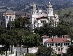


008- HEARST CASTLE-Publishing baron William Randolph Hearst was one of the most powerful people of his generation. The Hearst castle was built by William Randolph Hearst between 1919 to 1947 and died in 1951.It is located on the Central Coast of California in San Simeon, approximately 250 miles and 5 to 6 hours’ drive both from Los Angeles and San Francisco, after the Hearst death family fortunes declined and they gave it to the state and now a National Historic Landmark. It is a European architecture including the Spanish cathedral-like facade and Roman Baths. Despite its location far from any urban centre, the site attracts about one million visitors per year. It has 56 bedrooms, 61 bathrooms, 19 sitting rooms, 127 acres of garden, indoor and outdoor swimming pools, tennis courts, a movie theatre, an airfield, private zoo. The highlight of the estate is the outdoor swimming pool-Neptune Pool, located near the edge of the hilltop. All built to house Hearst’s specifications and to showcase his legendary art collection. The Hollywood and political elite often visited, usually flying into the estates airfield or taking a private Hearst owned train car from Los Angles. Charli Chaplin, Franklin Roosevelt, Winston Churchill were among Hearst A-list guests. A 40 minutes movie (Building The Dream) tells the story of Hearst Castle, from 8.15am to 6.45 pm is shown every 45 minutes in a five-story theatre in the visitor Centre, the cost is included in the tour ticket .There are three day time tours and each costing $22.50.There is 30 minutes travel time from the Visitor Centre and back by bus. And total time required is two hours, with 150 to 400 stairs and half-mile long walk.
i-Grand Room Museum Tour-$25.00 -It has Assembly Room-huge living room, Dining Room, Billiard Room, Theatre. The tour duration is 45 minutes.
ii- Upstairs Suites Museum Tour-$25.00
iii- Cottage & Kitchen Tour -$25.00
i-Grand Room Museum Tour-$25.00 -It has Assembly Room-huge living room, Dining Room, Billiard Room, Theatre. The tour duration is 45 minutes.
ii- Upstairs Suites Museum Tour-$25.00
iii- Cottage & Kitchen Tour -$25.00
