
TRAVEL JORDAN
{AMMAN-PETRA-WADI RUM-DEAD SEA-AQUABA}
{AMMAN-PETRA-WADI RUM-DEAD SEA-AQUABA}
GENERAL- Jordan is a gem in the Middle East. Apart from being the cradle of three modern religions, it is home to stunning natural and manmade wonders such as the Dead Sea, Wadi Rum, Petra and the Red Sea.
Jordan is an Arab Kingdom in Western Asia, on the East Bank of the Jordan River. Jordan is strategically located at the crossroads of Asia, Africa and Europe. The capital, Amman, is Jordan's most populous city as well as the country's economic, political and cultural centre.
Much of Jordan is covered by the Arabian Desert. However, the north-western part of Jordan is part of the Fertile Crescent. The government system is a constitutional monarchy, the chief of state is the king and the head of government is the prime minister.
Due to its central, strategic, geographical location and very close to Jerusalem and in between the main centres of Islam - Makkah, Damascus, Egypt and Iraq, few places are as blessed with as many holy sites, shrines and tombs as the Kingdom of Jordan. Many of God's Messengers, including The Founder of Islam, passed through Jordan.
Best Time to Visit-Amman, Petra and Wadi Rum all lie well over 800m above sea level, Dana and Ajloun are even higher (up to 1500m), whereas the Dead Sea lies 400m below sea level. The best time to visit Jordan is spring (March-April-May), when temperatures are good but not scorching. The worst of the rain is over by March.
Highway map- http://www.skyscrapercity.com/showthread.php? t=1459240
GEOGRAPHY- Jordan shares land borders with 5 countries- Saudi Arabia, Israel, Syria, Iraq, Palestine. Jordan is bounded to the north by Syria, to the east by Iraq, to the southeast and south by Saudi Arabia, and to the west by Israel and the West Bank. The West Bank area (so named because it lies just west of the Jordan River) was under Jordanian rule from 1948 to 1967, but in 1988 Jordan renounced its claims to the area. Its only port city is Aqaba, situated on the narrow Gulf of Aqaba, which empties into the Red Sea. Jordan's coastline stretches just 26 kilometres, or 16 miles. The highest point in Jordan is Jabal Umm al Dami, at 1,854 meters (6,083 feet). The lowest is the Dead Sea, at -430 meters. The Jordan River, approximately 186 miles (300 km) in length, draining the waters of Lake Tiberias (known as the Sea of Galilee) into the Dead Sea.
Jordan has three major regions (from east to west): the desert, the uplands east of the Jordan River, and the Jordan Valley. Only the northern highlands and the Jordan Valley have received enough rainfall to support large populations. Therefore, this area has always been more settled by farmers, villagers and townspeople. Most of the urban civilizations of Jordan have been based in these fertile lands. To the south and east, meanwhile, there is very little rainfall and no rivers for irrigation.
OLD HISTORY- From the west, Pharaonic Egypt extended its power and culture into Jordan, while the nomadic Nabateans built their empire in Jordan after migrating from the south of the Arabian Peninsula. Finally, Jordan was incorporated into the classical civilizations of Greece, Rome and Persia, the relics of which are scattered across the Jordanian landscape.
In biblical times, the country contained the lands of Edom, Moab, Ammon, and Bashan. Together with other Middle Eastern territories, Jordan passed in turn to the Assyrians, the Babylonians, the Persians, and, in about 330 B.C., to the Seleucids. Conflict between the Seleucids and the Ptolemies (Egyptians) enabled the Arabic-speaking Nabataeans to create a kingdom in southeast Jordan. In A.D. In 106 AD it became part of the Roman province of Arabia and in 633–636 was conquered by the Arabs. In the 16th century, Jordan passed to Ottoman Turkish rule and was administered from Damascus.
The Nabateans- Before Alexander’s conquest, a new civilization had emerged in southern Jordan. A nomadic tribe known as the Nabateans began migrating from Arabia during the sixth century BC. Over time, they abandoned their nomadic ways and settled in a number of places in southern Jordan, the Naqab desert in Palestine, and in northern Arabia. Their capital city was the Petra, Jordan’s most famous tourist attraction. Petra was inhabited by the Edomites before the arrival of the Nabateans, the latter carved grandiose buildings, temples and tombs out of solid sandstone rock. They also constructed a wall to fortify the city, although Petra was almost naturally defended by the surrounding sandstone mountains. Building an empire in the arid desert also forced the Nabateans to excel in water conservation. They were highly skilled water engineers, and irrigated their land with an extensive system of dams, canals and reservoirs.
The Nabateans were exceptionally skilled traders, facilitating commerce between China, India, the Far East, Egypt, Syria, Greece and Rome. They dealt in such goods as spices, incense, gold, animals, iron, copper, sugar, medicines, ivory, perfumes and fabrics, etc. From its origins as a fortress city, Petra became a wealthy commercial crossroads between the Arabian, Assyrian, Egyptian, Greek and Roman cultures.
The Age of Rome- Pompey’s (Romans) conquest of Jordan, Syria and Palestine in 63 BC, a period of Roman control which would last four centuries. In northern Jordan, the Greek cities of Philadelphia (Amman), Gerasa (Jerash), Gadara (Umm Qais), Pella and Arbila (Irbid) joined with other cities in Palestine and southern Syria. Under the influence of the Roman culture, Philadelphia (Amman) was reconstructed in typically grand Roman style with colonnaded streets, baths, an Amphitheatre, and impressive public buildings.
Of these, Jerash appears to have been the most splendid. It was one of the greatest provincial cities in Rome’s empire, and was honoured by a visit of the Emperor Hadrian himself in 130 AD. In southern Jordan, the Kingdom of Nabatea retained its independence until 106 AD, when Emperor Trajan’s forces took control of the region.
Christendom and the Byzantines- The Byzantine period dates from the year 324 AD, when the Emperor Constantine I founded Constantinople (Istanbul) as the capital of the Eastern Roman, or Byzantine, Empire. Constantine converted to the growing religion of Christianity in 333 AD. In Jordan, however, the Christian community had developed much earlier: Pella had been a centre of refuge for Christians fleeing persecution in Rome during the first century AD. During the Byzantine period, a great deal of construction took place throughout Jordan. All of the major cities of the Roman era continued to flourish, and the regional population boomed. As Christianity gradually became the accepted religion of the area in the fourth century, churches and chapels began to sprout up across Jordan.
One indication of the prosperity of the period can be seen in the mosaic floors which decorated many of these newly-built places of worship. These ornate mosaics often portrayed animals, people and towns. The most impressive examples of Byzantine mosaic artistry can be seen in Madaba, and the greatest of these is the famed sixth-century Map of the Holy Land, also known as the Mosaic Map of Palestine.
The Islamic Periods -The Arabs who swept northward on horse and camel-back were united by a common faith, of Islam. It took the Arabs only ten years to fully dismantle Byzantine control over the lands of Jordan, Palestine and Syria. In the year 636 AD, the Muslim armies overran the Transjordanian highlands and won a decisive battle against the Byzantines.
The Ottoman Empire- The four centuries of Ottoman rule (1516-1918 AD) were a period of general stagnation in Jordan. The Ottomans were primarily interested in Jordan in terms of its importance to the pilgrimage route to Mecca. They built a series of square fortresses—at Qasr al-Dab’a, Qasr Qatraneh, and Qal’at Hasa—to protect pilgrims from the desert tribes and to provide them with sources of food and water.
NEW HISTORY- Jordan is a young state that occupies an ancient land, one that bears the traces of many civilizations. Separated from ancient Palestine by the Jordan River, the region played a prominent role in biblical history. The ancient biblical kingdoms of Moab, Gilead, and Edom lie within its borders, as does the famed red stone city of Petra, the capital of the Nabatean kingdom and of the Roman province of Arabia Petraea.
After the Great Arab Revolt against the Ottomans in 1916 during World War I, the Ottoman Empire(who was with Germany) was partitioned by Britain and France . Britain and France agreed to divide up the region, as the mandatory powers, with France taking Syria and Lebanon, and Britain taking Palestine (now Jordan +Israel + Palestine = which included Transjordan, Israel was created on May 14, 1948 as a Jewish State ,and on 15 November 1988 unilaterally proclaimed the establishment of a new independent state called the "State of Palestine". ). In 1922, Britain assigned a Hashemite lord, Abdullah I, to govern Transjordan; his brother Faisal was appointed king of Syria, and later was moved to Iraq. The Emirate of Transjordan was established in 1921 by the then Emir Abdullah I and it became a British protectorate. In 1946, Jordan became an independent state. The name of the state was changed to Jordan in 1949.
https://www.aipac.org/learn/resources/maps/separation-of-transjordan
KINGS HIGHWAY-The King’s Highway is one of two routes that run from Amman to Petra. The King’s Highway starts in Northern Jordan near the town of Irbid and runs to south to the town of Wadi Musa (the gateway to Petra). The King’s Highway is marked with number 35. After Wadi Musa, the King’s Highway continues for a few more kilometers before it merges with Highway 47 to Aqaba. The King’s Highway from Amman to Petra is 249 km (154 miles) long. This is only slightly longer than the Desert Highway but because of the scenic nature of the route, the winding roads, the steep climbs, and descents, it will take you much longer.
The route of the King’s Highway in Jordan is over 5,000 years old and has been used as a trading route in ancient times. It was used by the Nabataeans to trade and the Roman used the route for trade, but also for military purposes.
AREA-89341Km2
POPULATION-98,83,000
CO-ORDINATES-31°57′N 35°56′E (Amman)
TIME ZONE-UTC+2 (summer UTC+3)
CLIMATE- The winter, lasting from November to March, is relatively cool, with temperatures averaging around 13 °C (55 °F). The best time to visit Jordan is spring (March–May), when temperatures are toasty but not scorching, wildflowers are out everywhere (even the desert is carpeted), and the hills and valleys running down the centre of the country are lush and gorgeously colourful.
CURRENCY-The currency of Jordan is the Jordanian Dinar (JOD).1JOD = 90.80INR & 1JOD=1.40USD
LANGUAGE- Arabic. Most Jordanians speak English, especially in urban area such as Amman and in areas that receive tourists and amongst younger people.
VISA- Single Entry visas valid for one month: 40 JOD (approximately 56 USD).
Jordan Pass- Waiving of tourist entry visa fees if you purchase the Jordan Pass before arrival to Jordan and stay a minimum of three nights (4 days). Once you’ve bought a Jordan Pass you’ve already basically prepaid for over 40 attractions (Petra-Jerash-Wadi Rum-Amman Citadal-Ajlon- etc). The Jordan Pass is valid for use within 12 months following date of purchase. But it will automatically expire after 2 weeks of the first time it is scanned in the first touristic attraction. The Jordan pass comes in 3 categories to suit all kinds of visits. 1-day visit to Petra will cost 70 JOD and free entry to over 40 attractions in Jordan. Jordan Pass cost was 70, 75 and 80 JOD for 1, 2 or 3 days in Petra respectively including Entry visa.(Petra entrance fee is typically 50-90 JOD and Visa is typically 50-60 JOD)
http://www.beontheroad.com/2016/05/jordan-visa-for-indians-visa-on-arrival.html#
https://bkpk.me/jordan-visa-for-indians-with-the-jordan-pass/
https://jordanpass.jo/Contents/How_it_Works.aspx

AIRPORT-Amman Queen Alia International Airport (IATA: AMM) is located in Zizya area, 20 miles (30km) south of Amman, the capital city of Jordan. It is the home hub of Royal Jordanian Airlines, the national flag carrier, and Jordan Aviation, Royal Falcon and Royal Wings as well. QAIA Airport or Amman Airport has one unique terminal, which is divided in three levels.
i-Arrival Level 1- It holds the arrivals area and the baggage claim area and a duty free shop. There is also the public area with retail shops, services (such as Banks, Prayer Room) and restaurants.
ii- Departure Level 2- Divides travellers between Jordanian passengers (E gates) and International passengers. There are not many facilities in this level.
iii- Departure Level 3- It has the passport control, access to departures gates and a lot of different services. It has the duty free area, several restaurants and bars, some retail shops, a pharmacy, a kids play area, a prayer area or departure gates among others.
Transportation-There are currently three options: -
i- Taxi: With fixed and public rates. Taxis operate 24 hours a day. Prices are fixed by law and are posted in the taxi park at the terminals exits. Taxi ride from the airport to Amman city centre should cost around JOD20.
ii- Bus Express: Called Sariyah Airport Express Bus, it runs to Amman every 30-60' during 24 hours/day. Depart every 30 minutes from 6:00am to 6pm, and every 60 minutes from 6pm to 12pm. The Express bus stop is outside the Terminal building. Travel time to/from the airport to Tabarbour bus station in Amman -with a stop at the 7th Circle- it takes about 45-60 minutes.
iii- Car Hire / Car Rental: Check prices and options here
Departure Fees-There is a departure fee of JOD10 (as of March 2015), imposed at all land and sea crossings. The departure fee of JOD30 (as of March 2015) for leaving Jordan by air is usually included in your airline ticket.
TRAVEL AMMAN
GENERAL-Amman (ancient Greek Philadelphia), the capital of Jordan, is a fascinating city of contrasts – a unique blend of old and new, ideally situated on a hilly area between the desert and the fertile Jordan Valley. Amman was originally built on seven hills, called Jabals (the Arabic word for mountain).
The Bible records that King David captured the city in the early 10th century BC; Uriah the Hittite, husband of King David's paramour Bathsheba, was killed here after the king ordered him to the front line of battle.
Everywhere there is evidence of the city's much older past. Due to the city's modern-day prosperity and temperate climate, almost half of Jordan's population is concentrated in the Amman area. The downtown area is much older and more traditional with smaller businesses producing and selling everything from fabulous jewellery to everyday household items. It is the residence of the king and the seat of government. Amman is Jordan’s chief commercial, financial, and international trade centre. The royal palaces are to the east; the Parliament is in the western section. Amman is Jordan’s chief transportation centre: two highways lead west toward Jerusalem, and one of the city’s main thoroughfares becomes the road to Al-Salṭ, to the northwest. Jordan’s main north-south highway, with its southern terminus at Al-ʿAqabah Port, runs through the city.
The University of Jordan (1962) and several museums and libraries, including the National Library, are located at Amman. Sites of interest include the remains of the ancient citadel, the adjoining archaeological museum, and a large, finely preserved Roman amphitheatre.
Amman is a relatively small city, and getting around is easy. Hotels, restaurants and tourist attractions are well known and could be reached easily by either taxis, which are metered and inexpensive, or by private transportation.
AMMAN HISTORY- In ancient times, Amman with its surrounding region was successively ruled by the then-superpowers of the Middle East: Assyria (8th century BC), Babylonia (6th century), the Ptolemies, the Seleucids (third century BC), Rome (1st century BC), and the Umayyads (7th century AD). Renamed "Philadelphia" after himself by Ptolemy II Philadelphus, the city was incorporated into Pompey the Great's province of Syria, and later into the province of Arabia created by Trajan (106 AD). Philadelphia prospered during Imperial times due to its advantageous location alongside Trajan's new trade and administrative road, the Via Nova Traiana.
When Transjordan passed into Arab rule in the 7th century AD, its Umayyad rulers restored the city's original name of Amman. Amman became the capital of the Emirate of Transjordan in 1921, and of the newly-created Hashemite Kingdom of Jordan in 1947.
AREA-1680Km2
POPULATION-40,00,000
CO-ORDINATES-31°57′N 35°56′E(Amman)
TIME ZONE-UTC+2 (summer UTC+3)
CLIMATE- Around the end of November is the period in which winter usually starts and continues from early to mid-March. Temperatures are usually near or below 17 °C (63 °F), with snow occasionally falling once or twice a year.
TEMP JAN FEB MAR APR MAY JUN JUL AUG SEP OCT NOV DEC
MAv 13 14 18 24 28 31 33 33 31 27 20 17
LAv 4 5 7 11 15 18 21 18 15 15 10 6
SIGHTS AND ATTRACTIONS AT AMMAN-

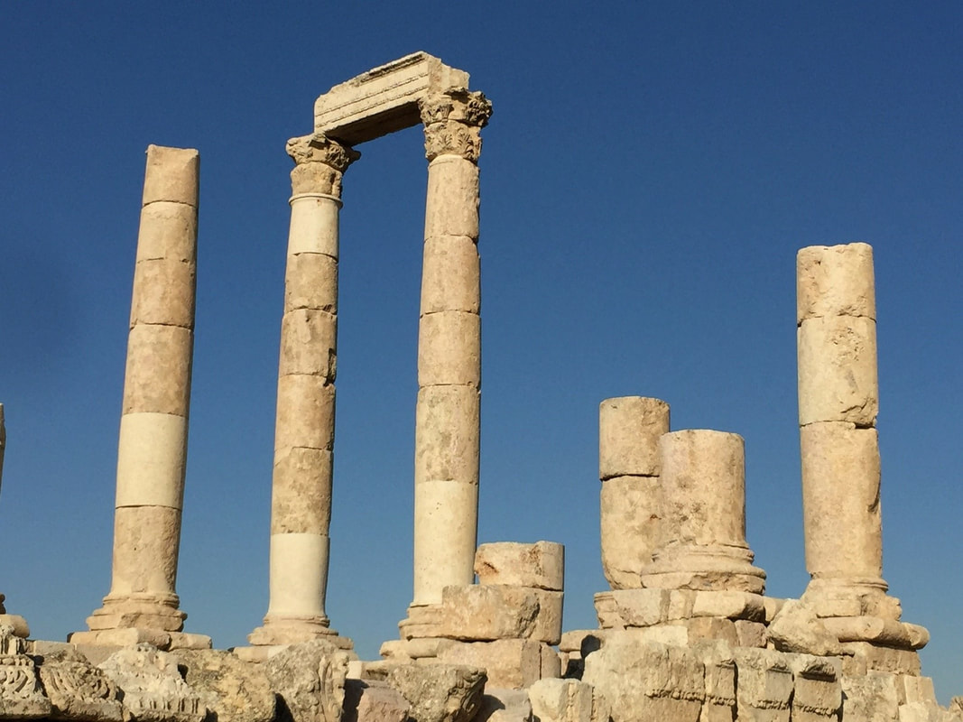
001-THE CITADEL, AMMAN-Jebel al-Qala’a, Amman’s highest hill (about 850m above sea level). Occupied since the Bronze Age, it's surrounded by a 1700m-long wall, which were rebuilt many times during the Bronze and Iron Ages, as well as the Roman, Byzantine and Umayyad periods. Artefacts dating from the Bronze Age show that the hill was a fortress and/or agora (open space for commerce and politics) for thousands of years.
Towering above downtown Amman, the site of the earliest fortifications is now subject to numerous excavations. Visitors in time through the stone-carved columns and vaulted chambers of the striking Temple of Hercules and Umayyad Palace. Farther down the hill, the impressive second-century Roman Theatre, the centre of ancient Philadelphia .The Citadel is, beside the Jordan Archaeological Museum, three important structures can be viewed:
Towering above downtown Amman, the site of the earliest fortifications is now subject to numerous excavations. Visitors in time through the stone-carved columns and vaulted chambers of the striking Temple of Hercules and Umayyad Palace. Farther down the hill, the impressive second-century Roman Theatre, the centre of ancient Philadelphia .The Citadel is, beside the Jordan Archaeological Museum, three important structures can be viewed:

a-The Byzantine Church-The remains of a small Byzantine Basilica. Corinthian columns mark the site, which is thought to date from the 6th or 7th century AD. Its nave is flanked by two rows of columns.

b-Temple of Hercules-About 100 meters south of the church is what is thought to have been the Temple of Hercules, today also known as the Great Temple of Amman. The temple was built in the reign of the Emperor Marcus Aurelius (161-180 AD). The two giant standing pillars are the remains of the Roman Temple of Hercules. The temple portico is framed by six 33-foot tall columns. The temple itself is 31m long by 26m wide; its outer temenos (sacred precinct) measures 122x72 meters. Once connected to the Forum (downtown). The only obvious remains are parts of the podium and the columns, which are visible from around town.

c-Umayyad Governer Palace Complex-The most impressive building of the Citadel is known simply as Al-Qaser (the Palace), which dates back to the Islamic Umayyad period around 720 AD. Its exact function is unknown, but the building includes a monumental gateway, cruciform audience hall and four vaulted chambers. A colonnaded street runs through the complex and to the north and east, ruins of the palace grounds are visible.
d-Cistern- Cistern, located to the right of the vestibule, was the primary water supply to the governor's palace. At 5m deep and 16m in diameter, it would have held just over 1,000 cubic meters, or approximately 250,000 gallons, of water. The cistern was fed by rainwater through an inlet channel, and could be entered for maintenance by the stairs shown in the photo. A column, whose stump is standing at the bottom of the cistern, measured the water level.
d-Cistern- Cistern, located to the right of the vestibule, was the primary water supply to the governor's palace. At 5m deep and 16m in diameter, it would have held just over 1,000 cubic meters, or approximately 250,000 gallons, of water. The cistern was fed by rainwater through an inlet channel, and could be entered for maintenance by the stairs shown in the photo. A column, whose stump is standing at the bottom of the cistern, measured the water level.

002-THE ROMAN AMPHITHEATER-An imposing monument set into the side of the mountain down the hill from the Citadel and connected to it via long and deep hidden tunnel. It is the most impressive legacy of Roman Philadelphia (Amman) built under Emperor Antoninus Pius (138-161 AD). Its 33 rows to seat 6000 spectators. It was built on three tiers: the rulers, of course, sat closest to the action, the military secured the middle section, and the general public perched and squinted from the top rows. Theatres often had religious significance, and the small shrine above the top row of seats once housed a statue of the goddess Athena (now in the National Archaeological Museum), who was prominent in the religious life of the city.
Acoustics of Amman Roman Theatre-The best part of the Amman Roman Theatre is its acoustics. You can stand at the centre of the stage and your voice will echo. The person sitting on top of the last row would be able to hear you clearly. People at opposite ends of the orchestra can talk to each other through the semi-circular stone wall below the first row of seats. Side entrances existed at ground level, one leading to the orchestra and the other to the stage. Rooms behind these entrances now house the Jordan Museum of Popular Tradition on the one side, and the Jordan Folklore Museum on the other side.
Acoustics of Amman Roman Theatre-The best part of the Amman Roman Theatre is its acoustics. You can stand at the centre of the stage and your voice will echo. The person sitting on top of the last row would be able to hear you clearly. People at opposite ends of the orchestra can talk to each other through the semi-circular stone wall below the first row of seats. Side entrances existed at ground level, one leading to the orchestra and the other to the stage. Rooms behind these entrances now house the Jordan Museum of Popular Tradition on the one side, and the Jordan Folklore Museum on the other side.
- The Forum was built in front of the Theatre under Commodus in 189-190 AD.
- The Odeon Theatre-Adjacent to the theatre and set on the east side of the Forum is the Odeon Theatre. It dates back to the late 2nd century AD. The lower seats of this monument, which could accommodate up to 500 spectators, have been restored and it is used occasionally for concerts.
- Nymphaeum-Roman cities always contained ornamental fountains, where water has always played such an important role, and Philadelphia was no exception. The main fountain or Nymphaeum, dedicated to the water nymphs, is close to the theatre complex and dates back to 191 AD.
- The museums of folklore and popular traditions- The Folklore Museum displays mannequins engaged in traditional crafts and a reconstruction of an old-fashioned living-room. The vaulted rooms are full of examples of national dress, with detailed notes and occasional photographs to set them in context.
- The Hashemite Plaza- The Hashemite Plaza includes open spaces, fountains, gardens, parking lots and cafes. It is equipped with a centre that hosts cultural activities like the Amman Book Festival. The plaza is flanked by two of the most popular Roman ruins of Amman, the Roman theatre and the Odeon, while the Nymphaeum is just a short distance away. The Citadel Hill, which towers over the Plaza, offers good views of it.

003-GRAND HUSSEINI MOSQUE, AMMAN- Al Husseini Mosque, the oldest mosque in Amman, has been the nexus of the capital's downtown area and an important gathering place for people of all walks of life.
This Ottoman style mosque was rebuilt in 1987, using striking pink-and-white stone in 1924 by the late King Abdullah I on the site of an ancient mosque built originally in 640 AD by Omar ibn Al-Khattab the 2nd Caliph of Islam.
The original mosque consisted of a prayer hall and courtyard, where people prayed, and a single minaret, from which the muezzin called to the faithful to perform the five daily prayers.
In 1921, after His Majesty the late King Abdullah I decided to make Amman his capital, he ordered the old mosque rebuilt. The project was completed in 1924, and the King decided to name the new mosque after his late father Sharif Hussein, the leader of the Great Arab Revolt.
One minaret was built in 1924, standing 13 metres tall, and a second minaret of matching size was added in 1952. Some renovations were made in 1987 during the reign of His Majesty the late King Hussein. Currently, the mosque has an area of 2,000 square metres and accommodates up to 2,600 worshipers.

004-KING ABDULLAH MOSQUE, AMMAN-This mosque located in El-Abdali district was completed in 1989, as a memorial to the late King Hussein’s Grandfather, His majesty as-Sayyid Abdullah I, King of Jordan. Located inside the mosque is the Islamic Museum, with a collection of pottery and photographs of His Majesty King Abdullah I. It is capped by a magnificent blue mosaic dome beneath which 3,000 Muslims may offer prayer. There is also a small women’s section for 500 worshippers, and a much smaller royal enclosure. The cavernous, octagonal prayer hall is capped by a magnificent blue dome 35m in diameter, decorated with Quranic inscriptions. This is the only mosque in Amman that openly welcomes non-Muslim visitors.

005-KING HUSSEIN BIN TALAL MOSQUE- King Hussein Bin Talal Mosque or simply King Hussein Mosque is the largest mosque in Jordan. Not to be confused with the 1924 Grand Al-Husseini Mosque, also known as King Hussein Mosque, from Downtown Amman.
King Hussein Mosque was built in 2005 in the reign of King Abdullah II in West Amman, specifically in Al Hussein Public Parks at King Abdullah II Street near King Hussein Medical Center.
King Hussein Bin Talal Mosque or simply King Hussein Mosque is the largest mosque in Jordan.
King Hussein Mosque was built in 2005 in the reign of King Abdullah II in West Amman, specifically in Al Hussein Public Parks at King Abdullah II Street near King Hussein Medical Center.
King Hussein Bin Talal Mosque or simply King Hussein Mosque is the largest mosque in Jordan.

006-JORDAN ARCHAEOLOGICAL MUSEUM-A small museum located at the Citadel that houses an excellent collection of antiquities ranging from prehistoric times to the 15th Century. Four exhibits are particularly worth viewing:
i- A collection of Dead Sea Scrolls found in 1952; one tells of treasure hidden on the west bank of the Jordan River.
ii- The Neolithic limestone statues of Ain Ghazal, which are linked to advances in pro-technology.
iii- A copy of the Mesha Stele or Moabite Stone, proudly erected by the Moabite King Mesha in 850 BC to celebrate his numerous victories over the Israelites.
iv- Four rare Iron-Age anthropomorphic sarcophagi of striking cocoon-like design, which give an insight into ancient burial practices.
Hours 9:00 - 17:00 in winter, 9:00 - 19:00 in summer, except on Fridays and official holidays 10:00 - 18:00
007-SOUK AL-BUKHARIA- The oldest souk in Amman, it is tucked away in an alley with little shops lining it left and right. For an authentic Jordanian shopping experience, head down to the souk and shop for lanterns, jewellery, antiques, and souvenirs.

008-RAINBOW STREET- This street in Jebel Amman is a destination in itself. Its original name was Abu Bakr al Siddiq street. The street runs east from the First Circle to Mango Street, and contains several attractions from roof tops restaurants to pubs. The street runs in front of the British Council building, as well as the headquarters of the Jordan Petroleum Refinery Company and the cinema after which the street is renamed. Ammanis come here every evening to promenade, and visit the many great cafes and restaurants – to see and be seen. Rainbow Street is for anyone in Amman. Lined with restaurants, cafés, shops, and cinemas, the street is a hive of activity, and a centre for Ammam’s nightlife. A terrific place to buy souvenirs, appreciate the old city, meet Jordanians, and sample local street food, a stroll along Rainbow Street is always pleasantly rewarded. Be sure to grab an ice cream from one of the many vendors around.

09- JERASH- Jerash, located 48 km north of Amman and nestled in a quiet valley among the mountains of Gilead, is the grandeur of Imperial Rome being one of the largest and most well preserved sites of Roman architecture in the World outside Italy.
To this day, its colonnaded streets, baths, theatres, plazas and arches remain in exceptional condition. Within the remaining city walls, archaeologists have found the ruins of settlements dating back to the Neolithic Age, indicating human occupation at this location for more than 6500 years.
It was not until the days of Alexander the Great that Jerash truly began to prosper. After falling under the rule of the Seleucid King Antioch in the second century BC, Jerash was conquered by the Roman Emperor Pompey in 63 BC.
Over the next century and a half, trade flourished with the Nabateans and Jerash prospered. The city also benefited from the rich surrounding farmlands and from iron ore mining in the Ajloun area. This period saw the implementation of a typically Roman city plan featuring a colonnaded main street intersected by two side streets.
The city received yet another boost in stature with the visit of Emperor Hadrian in 129 AD. To honour its guest, the citizens raised a monumental Triumphal Arch at the southern end of the city. Jerash's prosperity reached a peak in the beginning of the 3rd century, when it was bestowed with the rank of Roman Colony. During this "golden age", Jerash may have had a population of 20,000 people.
In third century AD, shipping progressed and Jerash thus fell into decline as its lucrative trade routes became less travelled and less valuable. Jerash was hit further by the Persian invasion of 614 AD and the Muslim conquest of 636 AD. A series of earthquakes in 749 AD did serious damage to the city and hastened its decline, and its population sank to 4000.
It was in 1806 that German explorer Ulrich Jasper Seetzen discovered them while searching for Oriental artefacts. After over 200 years of slow but steady excavation and the resettlement of today’s modern city across the wadi (valley), the area became the second biggest tourist destination in Jordan after Petra.
The modern city of Jerash can be found to the east of the ruins. While the old and new share a city wall.
Tickets to the ruins are available at the Jerash Visitors’ Center at the South Gate. There, you can also find free maps of Jerash as well as souvenir shops selling guidebooks and trinkets. The ruins are open from around 07:00 until dark. From July through October, sound and light shows take place from 20:30-22:30. You can visit the main ruins in a minimum of three to four hours.
The Jerash ruins can be easily walked in a couple of hours and it’s hard to miss anything important. The most notable sites are: -

i-Hadrian’s Arch- also known as the Triumphal Arch, which was built in AD 129 to honour the visit of Emperor Hadrian.
ii-Hippodrome:- a restored Roman-era stadium. This was the smallest of the two arenas in the Roman Empire. It is behind the arch, which hosted chariot races watched by up to 15,000 spectators.

iii-Forum (Oval Plaza):- This is the main attraction. The Oval Plaza (forum) is one of the most distinctive sites of Jerash, unusual because of its shape and huge size (90m long and 80m at its widest point). Fifty-six Ionic columns surround the paved limestone plaza, linking the cardo maximus with the Temple of Zeus.
iv- elegant remains of the Temple of Zeus-The built around AD 162, can be reached from the forum – a worthwhile climb if just for the view.
v-South Theatre: It is the larger of the two theatre, the South Theatre was built in the 1st century AD with a capacity of 5000 spectators. From the upper stalls, the acoustics are still wonderful as demonstrated by the occasional roving minstrel or drummer.
The site is still used for concerts, performances and even the occasional chariot race.
The site is still used for concerts, performances and even the occasional chariot race.
vi-The Cardo: a 600m (1,968ft) colonnaded street running the length of the city. The city’s main thoroughfare, also known as the colonnaded street. Stretching for 600m to the North Gate, the street is still paved with the original stones, rutted by the thousands of chariots that once jostled along its length.

vii-Nymphaeum: the main fountain of the city, before giving rise to a superb propylaeum or monumental gateway, and a staircase.
It is an ornate public fountain decorated with lion heads and dedicated to nymphs.
It is an ornate public fountain decorated with lion heads and dedicated to nymphs.
viii-Temple of Artemis: The Temple of Artemis, towering over Jerash at the top of the stairs, was dedicated to the patron goddess of the city, but alas was dismantled to provide masonry for new churches under Theodorius in AD 386.
ix-Agora: Once the city’s main food market positioned around a central fountain.
x-Jerash Archaeological Museum: Houses a collection of artefacts such as coins, statues and sarcophagi found during the numerous excavations.
ix-Agora: Once the city’s main food market positioned around a central fountain.
x-Jerash Archaeological Museum: Houses a collection of artefacts such as coins, statues and sarcophagi found during the numerous excavations.
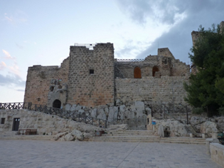
010-AJLUN- Just west of Jerash the castle of Ajlun is another highlight of northern Jordan. The town of Ajlun is about 3 kilometers from the castle. The Qalat er-Rabad, as the Ajlun Castle is locally knwon, and was the base of the Arab forces of Saladin, when he defeated the Crusaders in the 12th century. It was built as a military fort and buffer to protect the region from invading Crusader forces. The castle of Ajloun was built in 1184 by a nephew of Salah al-Din (Saladin to Westerners). Ajloun Castle is approximately 50 kilometers from the city of Amman that takes around one and a half hours by car and the city of Jerash is just a forty minute away. The castle commands views of the Jordan Valley and three wadis leading into it – making it an important strategic link in the defensive chain against the Crusaders, and a counterpoint to the Crusader Belvoir Fort on the Sea of Galilee (Lake Tiberias) in present-day Israel and the Palestinian Territories.
This superb example of Arab and Islamic architecture was built as a rectangle with four square towers and an entrance on the south side dominating a wide stretch of the north Jordan Valley and passages to it. From its hilltop position, the Castle of Ajloun protected the communication routes between south Jordan and Syria, and was one of a chain of forts, which lit beacons at night to pass signals from the Euphrates as far as Cairo. After the Crusader threat subsided, the castle was largely destroyed by Mongol invaders in 1260, only to be almost immediately rebuilt by the Mamluks.
This superb example of Arab and Islamic architecture was built as a rectangle with four square towers and an entrance on the south side dominating a wide stretch of the north Jordan Valley and passages to it. From its hilltop position, the Castle of Ajloun protected the communication routes between south Jordan and Syria, and was one of a chain of forts, which lit beacons at night to pass signals from the Euphrates as far as Cairo. After the Crusader threat subsided, the castle was largely destroyed by Mongol invaders in 1260, only to be almost immediately rebuilt by the Mamluks.
TRAVEL PETRA

GENERAL-Petra was once a thriving trading centre and the capital of the Nabataean empire between 400 B.C. and A.D. 106. The city of Petra, capital of the Nabataean Arabs, is one of the most famous archaeological sites in the world, it is located 240 km south of the capital Amman and 120 km north of the red sea town of Aqaba. Driving from Amman to Petra takes about three hours, or it’s just under two hours from Aqaba. Petra is also known as the rose-red city, a name it gets from the wonderful colour of the rock from which many of the city’s structures were carved. This Nabataean caravan-city, situated between the Red Sea and the Dead Sea.
On July 7, 2007 Petra was announced as one of the new Seven Wonders of the World and has become the perfect and best tourist destination. It is a vast, unique city, carved into the sheer rock face by the Nabataeans, an industrious Arab people who settled here more than 2000 years ago, turning it into an important junction for the silk, spice and other trade routes that linked China, India and southern Arabia with Egypt, Syria, Greece and Rome. Petra was later annexed to the Roman Empire and continued to thrive until a large earthquake in 363 AD destroyed much of the city in the 4th century AD.
The Nabataeans, an Arab tribe, first appeared in the sixth century BC in the desert located to the east of Jordan, and came from the south-east of the Arabian Peninsula. They settled first in Petra and subsequently expanded their territory to the Horan and Levant and finally announced Bosra as their capital.
The Nabataeans buried their dead in intricate tombs that were cut out of the mountain sides and the city also had temples, a theatre, and following the Roman annexation and later the Byzantine influence, a colonnaded street and churches. There are hundreds of elaborate rock-cut tombs with intricate carvings - unlike the houses, which were destroyed mostly by earthquakes, the tombs were carved to last throughout the afterlife and 500 have survived. Roman-style theatre, which could seat 3,000 people. There are obelisks, temples, sacrificial altars and colonnaded streets, and high above, overlooking the valley, is the impressive Ad-Deir Monastery – a flight of 800 rock cut steps takes you there.
Within the site there are also two excellent museums; the Petra Archaeological Museum, and the Petra Nabataean Museum both of which represent finds from excavations in the Petra region and an insight into Petra's colourful past.
The city sat empty and in near ruin for centuries. In 1812 a Swiss explorer named Johannes Burckhardt set out to ‘rediscover’ Petra; he dressed up as an Arab and convinced his Bedouin guide to take him to the lost city. After this, Petra became increasingly known in the West.
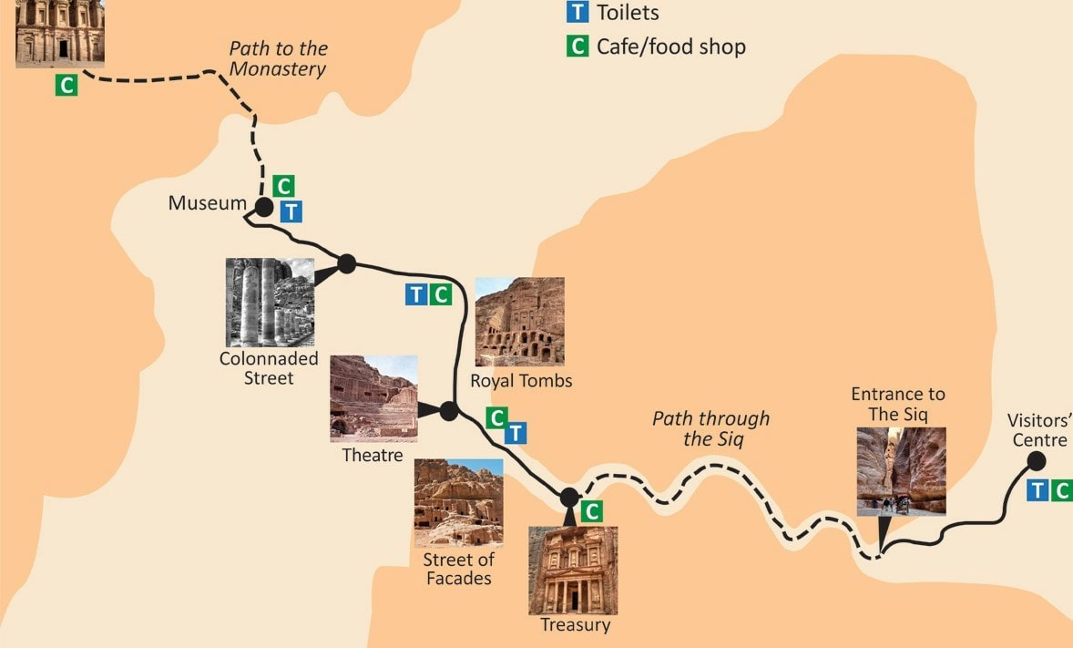
The only modes of transport allowed within Petra are on two feet or four (camel, donkey, or horse). There are 4 segments within Petra with 4 possible types of transport: from the entrance to the Siq (by foot or horse), from the Siq to the Treasury (by foot or cart), from the Treasury to the stairs of the Monastery (by foot, donkey or camel), the 800 stairs of the monastery (by foot or donkey). The prices for such rides are not set and are extremely negotiable, depending on one's bargaining abilities.
The length of main trail is about 4kms. A horse and carriage from the entrance to the Treasury costs 20 JD (two ways) and 40 JD to get to and from the main basin area. As the walk down to the Siq entrance is only 15 min. At a reasonable pace, it’ll take you around 30 minutes to walk from the entrance, along The Siq, to The Treasury. However, if you are reasonably fit and the weather is good, walking the whole of Petra is quite nice. Prefer climbing the Monastery's path before 15:00, otherwise it will be mostly in the shadow.
Petra’s Visitor Centre is open each day from 6am to 6pm during the summer and 6am to 4pm in the winter. This is the place to buy tickets, arrange a guide or pick up a Petra map.
Tickets-These are available at the Visitor Centre and can be purchased on arrival. Prices differ for foreigners and locals and a range of ticket types are available depending on the length of stay and number of visits to be made into Petra.
One Day Entry = 50 (J.D)
Carriages price: -Visitor centre to Museum and return -8 KM-40 JD
Petra by Night- Every Monday, Wednesday and Thursday there’s magical light show at Petra, with 1500 candles lighting the route to along The Siq to The Treasury. Along with the beautiful views, there are tales from local Bedouin people and live music.The experience begins at 8.30pm from Petra Visitor Centre and finishes at 10.30pm. Tickets cost 17 JD. You can find out more here: Petra By Night.
Destination Jan Feb Mar Apr May Jun Jul Aug Sep Oct Nov Dec
Temp Cent. 13 15 18 22 27 30 31 31 29 26 20 15
MM 36 31 30 11 4 0 0 0 0 2 13 33
On July 7, 2007 Petra was announced as one of the new Seven Wonders of the World and has become the perfect and best tourist destination. It is a vast, unique city, carved into the sheer rock face by the Nabataeans, an industrious Arab people who settled here more than 2000 years ago, turning it into an important junction for the silk, spice and other trade routes that linked China, India and southern Arabia with Egypt, Syria, Greece and Rome. Petra was later annexed to the Roman Empire and continued to thrive until a large earthquake in 363 AD destroyed much of the city in the 4th century AD.
The Nabataeans, an Arab tribe, first appeared in the sixth century BC in the desert located to the east of Jordan, and came from the south-east of the Arabian Peninsula. They settled first in Petra and subsequently expanded their territory to the Horan and Levant and finally announced Bosra as their capital.
The Nabataeans buried their dead in intricate tombs that were cut out of the mountain sides and the city also had temples, a theatre, and following the Roman annexation and later the Byzantine influence, a colonnaded street and churches. There are hundreds of elaborate rock-cut tombs with intricate carvings - unlike the houses, which were destroyed mostly by earthquakes, the tombs were carved to last throughout the afterlife and 500 have survived. Roman-style theatre, which could seat 3,000 people. There are obelisks, temples, sacrificial altars and colonnaded streets, and high above, overlooking the valley, is the impressive Ad-Deir Monastery – a flight of 800 rock cut steps takes you there.
Within the site there are also two excellent museums; the Petra Archaeological Museum, and the Petra Nabataean Museum both of which represent finds from excavations in the Petra region and an insight into Petra's colourful past.
The city sat empty and in near ruin for centuries. In 1812 a Swiss explorer named Johannes Burckhardt set out to ‘rediscover’ Petra; he dressed up as an Arab and convinced his Bedouin guide to take him to the lost city. After this, Petra became increasingly known in the West.
The only modes of transport allowed within Petra are on two feet or four (camel, donkey, or horse). There are 4 segments within Petra with 4 possible types of transport: from the entrance to the Siq (by foot or horse), from the Siq to the Treasury (by foot or cart), from the Treasury to the stairs of the Monastery (by foot, donkey or camel), the 800 stairs of the monastery (by foot or donkey). The prices for such rides are not set and are extremely negotiable, depending on one's bargaining abilities.
The length of main trail is about 4kms. A horse and carriage from the entrance to the Treasury costs 20 JD (two ways) and 40 JD to get to and from the main basin area. As the walk down to the Siq entrance is only 15 min. At a reasonable pace, it’ll take you around 30 minutes to walk from the entrance, along The Siq, to The Treasury. However, if you are reasonably fit and the weather is good, walking the whole of Petra is quite nice. Prefer climbing the Monastery's path before 15:00, otherwise it will be mostly in the shadow.
Petra’s Visitor Centre is open each day from 6am to 6pm during the summer and 6am to 4pm in the winter. This is the place to buy tickets, arrange a guide or pick up a Petra map.
Tickets-These are available at the Visitor Centre and can be purchased on arrival. Prices differ for foreigners and locals and a range of ticket types are available depending on the length of stay and number of visits to be made into Petra.
One Day Entry = 50 (J.D)
Carriages price: -Visitor centre to Museum and return -8 KM-40 JD
Petra by Night- Every Monday, Wednesday and Thursday there’s magical light show at Petra, with 1500 candles lighting the route to along The Siq to The Treasury. Along with the beautiful views, there are tales from local Bedouin people and live music.The experience begins at 8.30pm from Petra Visitor Centre and finishes at 10.30pm. Tickets cost 17 JD. You can find out more here: Petra By Night.
Destination Jan Feb Mar Apr May Jun Jul Aug Sep Oct Nov Dec
Temp Cent. 13 15 18 22 27 30 31 31 29 26 20 15
MM 36 31 30 11 4 0 0 0 0 2 13 33
PETRA ATTRACTIONS ON THE WALKWAY

i-The Siq- Upon entering the park, you’ll walk for 10-15 minutes downhill on a boring gravel path, then the path levels out and you’ve reached the Siq, the famous canyon walls leading into Petra. Take your time through this area and appreciate the massive stone walls and mesmerizing curving colored stripes. The Siq, the main road that leads to the city, starts from the Dam and ends at the Treasury. It is a rock canal that measures 160 meters in length, 3 to 12 meters in width and reaches up to 80 meters in height. The main part of the Siq is created by natural rock formation and the rest is carved by the Nabataeans. At the beginning of the Siq, one can still view the remains of the city’s gate. On both sides of the Siq, there are channels to draw water from Wadi Musa (the Valley of Moses), from outside the city to the inside. The floor of the Siq is paved with stone slabs, part of which can be viewed in its original location. From the right, it is evident that the water flowed through pottery pipes but the left channel is carved from the rock and covered with panels of stone, and there are spaces in place to filter water.

ii- The Dam- At the start of the Siq the original Nabataean dams are visible, and these prevented the flooding in the Siq, and collected water for use. The dam protected the city of Petra by redirecting the flood waters into a tunnel, which was later titled the ‘Dark Tunnel’. Proving to be successful, the dam thus represented the Natabataean’s skilful and modern infrastructure.

iii- The Treasury (Al Khazna)- The Siq dead-ends into a large plaza dominated by the iconic Treasury façade. The siq opens up onto Petra’s most magnificent façade; the Treasury, or Al Khazna. It is almost 40 meters high and intricately decorated with Corinthian capitals, friezes, figures and more. The Treasury is crowned by a funerary urn, which according to local legend conceals a pharaoh’s treasure. Although the original function is still a mystery. The Treasury was probably constructed in the 1st century BC. However, in reality the urn represented a memorial for royalty. The Treasury consists of two floors with a width of 25 meters and a height of 40 meters. The purpose of the Treasury is unclear: some archaeologists believed it to be a temple, while others thought it was a place to store documents. However, the most recent excavation here has unearthed a graveyard beneath the Treasury. The Treasury comprises three chambers, a middle chamber with one on either side, the elaborately carved facade represents the Nabataean engineering genius.

iv- The Street of Facades (outer Siq)- After leaving the Treasury, you’ll walk along the Street of Facades . It is a name given to the row of monumental Nabataean tombs carved in the southern cliff face that lies past the Treasury and adjacent to the outer Siq, that when you pass the Treasury, the Siq begins to widen gradually as it reaches into an open area. On both sides, there are a number of Nabataean burial interfaces decorated with grindstones along with other decorations.

v- The Theatre- At the end of the Street of Facades is the 7000-seat Roman Theater. The theatre was created by the Nabateans but later enlarged by the Romans. It is still used for occasional performances. Once you get through the Street of Facades and past the amphitheatre, you’ll come around a corner that opens up into a large town square.
vi-The Colonnaded Street- After you pass the amphitheatre and that big plaza, you’ll walk down the Colonnaded Street, lined with Roman columns leading up to a pretty sweet gate.
vi-The Colonnaded Street- After you pass the amphitheatre and that big plaza, you’ll walk down the Colonnaded Street, lined with Roman columns leading up to a pretty sweet gate.

vi-Monastery (ad-Deir).- The largest carved monument in Petra, dates back to the 1st century AD. The interior, like that of the Treasury, is puny in comparison to the facade. The more than 800 steps up to the Monastery can take over an hour, and even if you take a donkey, you will have to walk and climb for about 10 minutes near the end.
TRAVEL WADI RUM
TRAVEL WADI RUM

GENERAL-Wadi Rum also known as The Valley of the Moon is a valley cut into the sandstone and granite rock in southern Jordan 60 km (37 mi) to the east of Aqaba or about 1.5 hours from Petra. It is the largest Wadi in Jordan. Jordan’s Wadi Rum is one of the world’s most beautiful deserts, filled with magnificent rose sandstone mountains, canyons & dunes. Wadi Rum itself was made famous by the exploits of Lawrence of Arabia during World War I, later becoming the setting for the film of the same name. Movies buffs also may recognize the landscape from several films, including Lawrence of Arabia, Transformers: Revenge of the Fallen, where the desert masqueraded as Egypt, and Red Planet. Wadi Rum is now acknowledged as one of the world’s foremost desert climbing and hiking areas. Wadi Rum is a short detour from the Desert Highway between Amman and Aqaba. A side road leads to the entrance where you will find the Wadi Rum Visitors Centre. Wadi Rum village is 5kms further along the road after leaving the Visitors Centre. The cost to enter into Wadi Rum Protected Area is 5 Jordanian dinars (JOD5) per person.
Upon reaching the entrance to the Wadi Rum Tourist Centre, visitors will find themselves in a welcome pavilion accompanied by other tourists getting ready for a day of sightseeing. Once you step outside of the pavilion, be sure to look out for the famous Seven Pillars rock formation, which is a mountain with seven deep vertical ridges.
Mount Rum in Wadi Rum stands at 1734 m above sea level. The mountain was named the Seven Pillars of Wisdom (for its shape as seven pillars) by Lawrence of Arabia.
Wadi Rum is home to the Zalabia Bedouin who, working with climbers and trekkers, have made a success of developing eco-adventure tourism, now their main source of income.
The area is now also one of Jordan’s important tourist destinations, and attracts an increasing number of foreign tourists, particularly trekkers and climbers, but also for camel and horse safari or simply ‘day-trippers’ from Aqaba or Petra. Popular activities in the desert environment include camping under the stars, riding Arab horses, hiking and rock-climbing amongst the massive rock formations. Jabal Rum (1734 metres above sea level) is the second highest peak in Jordan and the highest peak in the central Rum. The village of Wadi Rum consists of several hundred Bedouin inhabitants with their goat-hair tents and concrete houses, one school for boys and one for girls, a few shops, and the headquarters of the Desert Patrol.
SHOOTING STARS IN WADI RUM- In August, November and December during the meteor showers of Perseid, Leonid and Geminid we can see up to tens of shooting star per hour. A spectacular phenomenon of nature. Shooting stars are in fact meteors. Space dust and rocks that originating from asteroids and comets. The dust or rock enters our atmosphere at a very high speed. The resistance of our atmosphere heats the rock rapidly. The bright streak is actually not the rock burning. But the glowing hot air as the hot rock passed through the atmosphere. Each year in August we can see the shooting stars from Perseid. Most of the time the first shooting stars from Perseid are seen as early as mid-July. And the last around the mid-August. The peak is between the 9th and 13th of August. How much we can see from this extraordinary phenomenon largely depends on the moon. The website timeanddate.com offers great information on the Perseid and other meteor showers.

i-WADI RUM NIGHT LUXURY CAMP- It is 8 km from Rum Village and Visitors’ Centre inside the protected area (15 minutes’ drive).

ii-Camel Tour-The Safari Driver (Bedouins are the only ones allowed by local authority of protected area, to drive in Wadi Rum) will meet you in the Rest House of Wadi Rum village and will escort you on a stunning journey through the desert of Wadi Rum. You will start or end your journey by approximately an hour camel ride across the desert to Lawrence Springs. (Duration 2hour)
Price-30JD/person for a minimum of two people.
Price-30JD/person for a minimum of two people.

iii-Desert 4x4 Safari-Jeep tours are the best way to see the most of what Wadi Rum has to offer. From here, you experience the most incredible desert by 4×4 tour for the rest of your journey, which will end by magnificent view of the sun drop under the horizon. These will include Lawrence’s Spring, Khazali Canyon, the sand dunes and the Nabatean Map inscription. (Duration 2hours)
Price: 1pax 30JD, 2pax 20JD, 3-4pax 15JD
Price: 1pax 30JD, 2pax 20JD, 3-4pax 15JD

iv-Camp (sleep under the stars) -Your Luxury Bedouin camp, lit with the gentle flames of traditional lamps is nestled inside a private Royal desert retreat. Your Luxury camp complete with hot running water, showers, flushing toilets, ceramic sinks, spa products. The luxury Glamping tents offer you the opportunity to enjoy beautiful scenery of the Sandstone Mountains of Wadi Rum spectacular desert without giving up the comforts of home. At of Wadi Rum Night Luxury Camp you will enjoy a scrumptious dinner. After dinner, relax beside a bonfire and enjoy the star filled night sky. In the morning, awake to the smell of freshly brewed coffee, and a freshly cooked Arabic breakfast.
This is a rare opportunity to glimpse into the rich history of the region, experience pristine desert, observe native wildlife, enjoy a stunning journey through Wadi Rum protected area.
This is a rare opportunity to glimpse into the rich history of the region, experience pristine desert, observe native wildlife, enjoy a stunning journey through Wadi Rum protected area.

v-Um frouth Rock bridge:-It is an arch of the Rock, which you can clim it, and have nice photos while you are on the bridge.

vi-Nabatean Temple :- It is an old building was surrounded by sands before explore it. It is setting nearby to Wadi Rum village. There you can have nice pictures for some hight mountains in Wadi Rum. It was Used by Nabateans to worship ALLAT (Goddess). This temple was built on the ruins of Allat temple of the AAD TRIBE.

vii-Lawrence Spring: -There is Natural water spring, where you can walk up on the mountain to see the water and very nice view for the desert. Lawrence Spring offers visitors a chance to see several ancient inscriptions.
TRAVEL DEAD SEA
TRAVEL DEAD SEA


01-DEAD SEA-
i-Bath in Dead Sea- Make sure you don’t have any injuries on your skin before you enter the water or spread the mud on yourself because the salt burns them. Don’t let the water go in your eyes, too. If it happens, rinse them very well with fresh water from the showers. In any case, take a thorough shower after floating in the Dead Sea and rub off all the mud. Don’t swallow the sea water, not only tastes utterly bitter, it can also make you retch. There is a mud stand where people just dig their hands into a mud tub near the shire and scoop up the mud for a facial session – for free. Besides the mineral rich waters of the sea, the black mud from the sea bed is said to have rejuvenating effect on aging skin. It has also been processed and packed into a wide range of cosmetic products. For the best effect, we should keep the mud on our bodies for 30 minutes. For the 30 minutes we walked along the coast of the Dead Sea.
The composition of the Dead Sea Bath Salt is also unique, consist of potassium, calcium, magnesium, chlorides, bromides, Zinc, Sulphate and many other Minerals that don’t exist in any other salts, and it is strictly for Bathing.

ii-Amman Touristic Beach- Amman Beach is your best option to enjoy the benefits of this unique mineral water without having to pay the crazy prizes for the 4 and 5 star Dead Sea hotels. Situated on the Dead Sea main road, two kilometres after the hotels area. Amman Touristic Beach offers swimming pools and changing rooms for low budget travellers and locals for minimal fees. Amman Touristic Beach is an ideal location for beach parties and events. The grounds are attractively landscaped and the beach is clean, with sun umbrellas, freshwater showers and a vibrant local flavour. There is a small water fall coming from a hot spring that can serve as a shower afterwards to wash off the salt from your skin. Entrance fee is 10 JD. The dead sea clay collected is available for 3JD and they may also help you with applying it on your body.
iii- The other area – entry is to the right of the main entrance – has a swimming pool and better facilities: women can feel comfortable wearing a bikini, there are lots of loungers (free), you can hire towels and the lockers are usable.
iv-Hotel Beaches-Many hotels also sell day passes that include full use of hotel facilities as well as their Dead Sea beachfronts; at the Mövenpick Resort, day passes cost 20 JD per person for hotel guests, while non-hotel guests pay 40 JD on weekdays and 50 JD on weekend. Dead sea clay will be freely available in these places for visitors to use.
a-Marriott Dead Sea "day pass", includes food/drink, for 55 JOD.
b- Holiday Inn Resort Dead Sea , 25 JOD.
http://byblok.com/listings/holiday-inn-resort-dead-sea/
https://www.bookingjordan.com/blog/Fun-at-the-Dead-Sea-Jordan
002-BETHANY BEYOND THE JORDAN- Situated on the eastern bank of the River Jordan, nine kilometres north of the Dead Sea, the archaeological site consists of two distinct areas: Tell Al-Kharrar, also known as Jabal Mar-Elias (Elijah’s Hill) and the area of the churches of Saint John the Baptist near the river. Situated in a pristine natural environment the site is believed to be the location where Jesus of Nazareth was baptized by John the Baptist. It features Roman and Byzantine remains including churches and chapels, a monastery, caves that have been used by hermits and pools in which baptisms were celebrated, testifying to the religious character of the place. The site is a Christian place of pilgrimage.
Since the excavations of the late 1990s, the site has been extensively developed by the Jordan Tourism Authority, but sensitively so - visitor numbers are controlled and the Visitors' Centre has been located at some distance from the site in an effort to preserve its sanctity. From ticket office, an electric minibus brings visitors to their choice of three different sites: Tell Mar Elias, the Baptism Pools and/or John the Baptist's Church.
Since the excavations of the late 1990s, the site has been extensively developed by the Jordan Tourism Authority, but sensitively so - visitor numbers are controlled and the Visitors' Centre has been located at some distance from the site in an effort to preserve its sanctity. From ticket office, an electric minibus brings visitors to their choice of three different sites: Tell Mar Elias, the Baptism Pools and/or John the Baptist's Church.

003-MADABA- Just 30km from Amman, along the 5,000-year-old Kings´ Highway, is one of the most memorable places in the Holy Land. After passing through many ancient sites, the first city you reach is Madaba, known as the “City of Mosaics”. Madaba is home to the famous 6th century Mosaic Map of Jerusalem and the Holy Land.
The Map of Madaba mosaic was discovered in 1896 and the findings were published a year later. This discovery drew the attention of scholars worldwide. Madaba became known as the "City of Mosaics" in Jordan.
The Madaba Mosaic Map covers the floor of the Greek Orthodox Church of St. George, which is located northwest of the city centre. The mosaic panel enclosing the Map was originally around 15.6 X 6m, 94 sq.m., only about a quarter of which is preserved. The Madaba Mosaic Map is an index map of the region, dating from the sixth century AD, preserved in the floor of the Greek Orthodox Basilica of Saint George. With two million pieces of coloured stone, the map depicts hills and valleys, villages and towns in Palestine and the Nile Delta. The mosaic contains the earliest extant representation of Byzantine Jerusalem, labelled the "Holy City." The map provides important details as to its 6th century landmarks, with the cardo, or central colonnaded street and the Holy Sepulchre clearly visible. This map is one key in developing scholarly knowledge about the physical layout of Jerusalem after its destruction and rebuilding in 70 AD.
Other mosaic masterpieces found in the Church of the Virgin and the Apostles and the Archaeological Museum, depict a profusion of flowers and plants, birds and fish, animals and exotic beasts, as well as scenes from mythology and everyday pursuits of hunting, fishing and farming. Hundreds of other mosaics from the 5th through the 7th centuries are scattered throughout Madaba.
Close to the Church of the Virgin is the Madaba Institute for Mosaic Art and Restoration, which operates under the patronage of the Ministry of Tourism. The only project of its kind in the Middle East, the Institute trains artisans in the art of making, repairing and restoring mosaics.

004-MOUNT NEBO- Mt. Nebo is where Moses is said to have received his glimpse of the Promised Land. Mount Nebo is one of the most revered holy sites of Jordan, located 10 km west of the Roman Byzantine town of Madaba, for this is where Moses was buried.
Mount Nebo is the presumed site of his death and burial place, and a center for pilgrimages since earliest Christian times. A small Byzantine church was built there by early Christians, which has been expanded into a vast complex. During his visit to Jordan in 2000, the Late Pope John Paul II held a sermon here that was attended by some 20,000 faithful. Mount Nebo's first church was constructed in the 2nd half of the 4th century to commemorate the place of Moses' death. Six tombs have been found hollowed from the natural rock beneath the mosaic-covered floor of the church.
The restoration work preserved for future generations this extraordinary Monument of the Faith and brought new life to a sanctuary constructed in ancient times to honor Moses, the Prophet and man of God. Since September 4, 1976, the annual feast of Moses is celebrated and the Christian community join with the Franciscan Fathers in this solemnity.
In the Bible
Then Moses climbed Mount Nebo from the plains of Moab to the top of Pisgah, across from Jericho. There the Lord showed him the whole land.... Then the Lord said to him, "This is the land I promised on oath to Abraham, Isaac and Jacob when I said, 'I will give it to your descendents.' I have let you see it with your eyes, but you will not cross over into it."
And Moses the servant of the Lord died there in Moab, as the Lord had said. He buried him in Moab, in the valley opposite Beth Peor, but to this day on one knows where his grave is.

005-HAMMAMAT MA'IN- Ma’In Hot Springs Resort & Spa is located 30 kilometres from the ‘mosaic’ city of Madaba and right of the corner of the Dead Sea. It is a scenic 60-minute drive from Amman Queen Alia International Airport (AMM). Hammamat Ma'in (also called Zarqa Ma'in) is a series of natural hot springs and waterfalls with biblical connections, located between Madaba and the Dead Sea in Jordan. Hammamat Ma’in, the thermal mineral springs that for centuries have attracted people to come and immerse themselves in the sites’ warm therapeutic waters. This water is heated to temperatures of up to 63° Celsius by underground lava fissures as it makes its way through the valley before emptying into the Zarqa River.
The most famous thermal spring in the hills above the Dead Sea is Hammamat Ma’in, a resort in Wadi Zarqa Ma’in. here the water, ranging from 45°C to a blistering 60°C, tumbles off the hillside in a series of waterfalls and less assuming trickles, and is collected in a variety of pools for public bathing. It contains potassium, magnesium and calcium. The entrance fee permits use of the Roman baths at the base of the waterfall closest to the entrance.
There is an excellent 5-star hotel here, which offers indoor and natural outdoor hot pools, a swimming pool and spa facilities. There’s a separate charge for use of the Hammamat Ma'in swimming pool (JD13). The entry fee also includes a sandwich and a cold drink from the complex shop. Visitors are requested not to bring their own picnic, but this is rarely enforced. The valley is hugely popular on Friday during spring and autumn. The resort is 18.5km from the Dead Sea Resorts and 27km from Madaba, and well signposted in either direction. From Madaba a taxi costs JD10 one way, or JD20 for a return journey including around an hour’s waiting time.

006-THE SIQ TRAIL, WADI MUJIB- Wadi Mujib, is a river canyon, which enters the Dead Sea c 420 metres (1,380 ft) below sea level. The Mujib Reserve of Wadi Mujib is located in the mountainous landscape to the east of the Dead Sea. This 1,300-metre (4,300 ft.) variation in elevation, combined with the valley's year round water flow from seven tributaries. Trekking through the lowest nature reserve in the world is most thrilling. Operated by The Royal Society for the Conservation of Nature. You can book your Wadi Mujib trek at the office right off the main highway between Aqaba and the Dead Sea resort area. You'll need a dry bag if you want to bring along your phone, camera or electricals as there are sections where you will need to swim. Otherwise it is best to leave them in a locker at the start. For the first few hundred metres the water gets gradually deeper reaching your knees, then your waist. The first half an hour is mainly wading through the water, pretty easy aside from a few sections of particularly fast water. This canyon which has been carved out by centuries of rain and flowing water is spectacular, with its orange walls, bright blue water. Overall the Siq Trail takes 1-2 hours depending on how far you want to go and how many pictures you stop to take.
The hiking season at Wadi Mujib is generally from April 1 - October 31. The Siq Trail opens at 8am and closes at 3pm. The Siq Trail cost 21 JD per person (approximately $30 USD). You can hire waterproof shoes for 5 JD ($7 USD).
The hiking season at Wadi Mujib is generally from April 1 - October 31. The Siq Trail opens at 8am and closes at 3pm. The Siq Trail cost 21 JD per person (approximately $30 USD). You can hire waterproof shoes for 5 JD ($7 USD).
TRAVEL READ SEA (AQABA)

GENERAL- Aqaba is a resort city and a port city, with tourism a major industry. Amman to Aqaba is about 350km using the Desert Highway (highway 15 and Highway 47). It will take about 4 hours to travel this distance at a good speed. Jordan's splendid Red Sea resort. Aqaba is a fun place. Aqaba's greatest asset is the Red Sea itself. It was a prime junction for land and sea routes from Asia, Africa and Europe. Jordan’s only coastal city sits on the Gulf of Aqaba and is home to the country’s only seaport. The temperate climate and gentle water currents have created a perfect environment for the growth of corals and a teeming plethora of marine life. Here you can swim with friendly sea turtles and dolphins. Here you can experience some of the best snorkelling and diving in the world. For those who do not wants to go in waters and get wet, all the deep sea wonders can be viewed through a glass-bottomed boat or by submarine, or you can just relax under the sun on the resort's sandy beaches. Plus, of course, there are plenty of other water-sport activities available, as well as an extensive and interesting Marine Park. Aqaba's location next to Wadi Rum and Petra has placed it in Jordan's golden triangle of tourism.
Aqaba sits at the northern tip of the ‘Gulf of Aqaba’, the northern-most part of the Red Sea, at the crossroads of the continents of Asia, Africa, and Europe. The city has a rich history, having been inhabited for over 4000 years. The city’s airport, King Hussain International Airport sits a few kilometers north of the center, near the Arava Border Crossing with Israel. In Jordan, there are 27 kilometers of coastline found along the Red Sea. The water in the Red Sea in Jordan is actually 35% saltier than most seas, which provides several health benefits to swimmers. The high salinity increases circulation and is known to help with skin conditions.
Snorkeling is the best way to explore Aqaba’s ocean floor and its wondrous coral reef. The Red Sea’s water temperature is perfect for swimming and diving, and is buzzing with life. You might think you are in a tropical fish tank while you take in the lush aquatic surroundings. The ocean floor is both colorful and lively, and will make for an ideal family outing. The area boasts 25 different diving spots; most are within the Aqaba Marine Park.
While it is called the Red Sea, it is not exactly red. It is named for a specific type of algae that is found in the water that gives a reddish-brown color. It is believed that the name also comes from the red mountains that surround the sea.
Aqaba International Airport is situated just 20 minutes from the town centre and services regular flights from Amman as well as from several European cities. From the town centre, the borders of Israel, Egypt's Sinai and Saudi Arabia are no more than a 30-minute drive.
Destination Jan Feb Mar Apr May Jun Jul Aug Sep Oct Nov Dec
TEMP. 20 22 25 29 34 37 38 38 35 32 26 21
RAINS in mm 5 6 5 3 1 0 0 0 0 1 3 5

01-AQUABA-
i-Inside the City-There are no spectacular coral reefs in the inner city so these beaches are best for swimming, sunbathing and some water sports only:
InterContinental Beach
Kempinski Beach
Movenpick Beach
ii-Palm Beach-The free public beach of Al-Hafayer, also recently known as ‘Palm Beach’, is located on the southern coast, some 10 minutes from downtown. This is the perfect place to enjoy a pleasant sunset with some tea and grab a taste of Aqaba life among friendly locals on their leisure time.
iii-Tala Bay Beach Club-Tala Bay Beach Club is part of Tala Bay, an integrated residential and tourism resort, located 14 kms to the South from the center of Aqaba. For an entrance fee of 20 JD. There is also a shuttle bus between the downtown and Tala Bay, picking up passengers at other hotels and in front of Mohannad supermarket on Al-Kornish street, opposite Dweik 2 hotel.
iv-Berenice Beach Club-Berenice Beach Club is the best way to spend a day at the beach. Only a short bus rides away from the city centre, this private club is spread across 500m of the Red Sea coast and boasts some cleanest waters in the Aqaba Marine Park. It is equipped with all the facilities you could wish for, including three swimming pools, an eatery and, of course, showers and shaded sunbeds. Services on offer range from diving and snorkelling at an in-house diving centre, yacht cruises, Jet Ski rides, and all sorts of other water sports activities. At Berenice Beach Club we have three freshwater pools which are also heated in winter. The landscaped infinity pool allows breath taking, panoramic sea views.

v-Aqaba Marine Park-This snorkelling spot is located 6 miles (10km) to the south of the Aqaba city centre. You can enter the water anywhere along the beach. The spot to explore covers a wide area between the beach and the reef drop-off, about one hundred yards apart. Due to the position of Aqaba at the north end of the gulf there is very little current most of the time and the sea is rarely rough varying from flat calm to a slight chop. The temperature of the water is 22 degrees Celsius in the winter, full wet suit advised, to a balmy 27 degrees Celcius in the Summer months when a shorty or event shirt is sufficient.
TOURS OF JORDAN (EXAMPLE) –
DAY-1 |
ON THE GO TOURS https://www.onthegotours.com/Jordan/Totally-Jordan-8-Days#itinerary Totally Jordan - 8 Days FROM: INR 105,825 Land Only Group Amman Welcome to Jordan and the start of an amazing adventure. Arrive Amman, included transfer to our hotel and overnight. Overnight: Amman |
DAY-2 |
Ancient Cities & Roman Ruins Amman - Jerash - Umm Qais - Amman. Heading north, we visit Jerash, and more before continuing to Umm Qais (Gadara), a dramatic black-basalt Roman city of the Decapolis with panoramic views over the Sea of Galilee and the Golan Heights. Later this evening we head out for a meal and a stroll along Rainbow Street. Overnight: Amman | Breakfast, Dinner |
DAY-3 |
Mt Nebo & Umm ar Rasas Amman - Madaba - Mount Nebo - Umm ar Rasas - Petra. Today we tour the citadel and Archaeological Museum of Amman. Leaving Amman we’ll stop first at Mt. Nebo, the site from which Moses saw the Promised Land. This amazing panorama includes the Jordan River Valley, the Dead Sea, Jericho and the spires and domes of the Mt. of Olives and Bethlehem on the Judean hills just across the wide valley. Later we visit Madaba en route to Petra where we see the Church of St George, the Madaba Archaeological Park, Apostles Church and Madaba Museum. Our next port of call is Um ar-Rasas, one of Jordan’s World Heritage sites and once an important stop on the busy caravan routes. The impressive mosaic floor of the St. Stephen Church features medallions commemorating all the early Christian pilgrimage sites of the region, and the extensive ruins also include one of the area’s earliest Stylite towers, where a Byzantine hermit lived atop the tower and preached to the pilgrimage visitors. Our final stop of the day is Petra. Consider doing a Petra by Night excursion (payable locally) for a tantalizing candlelight stroll through Petra’s Siq….a romantic preview of things to come. Overnight: Petra | Breakfast |
DAY-4 |
The Rose City of Petra We access the hidden archaeological treasures of the Rose City on a walk through a narrow, deep siq, where the rocks finally give way to reveal the famous facade of Al-Khazneh (the Treasury). Continuing our walk, we’ll then go on to explore chunks of this fantastic once-lost city which is full of tombs, temples, an impressive amphitheatre and a Roman colonnaded street. The intrepid can ascend the hundreds of rock-cut steps to Ad-Deir. Better known as the Monastery, Ad-Deir has a similar facade to that of the Treasury. Overnight: Petra | Breakfast |
DAY-5 |
Wadi Rum desert Petra - Wadi Rum. There is a chance to revisit Petra this morning before our afternoon drive to Wadi Rum. A vast, silent landscape of ancient riverbeds, pastel coloured stretches of sandy desert and amazing rock formations known as jebels that rise from the desert floor awaits. Boarding 4x4 jeeps, we take an exhilarating desert safari across the sand dunes, taking in the breath-taking scenery of Wadi Rum. Tonight, we enjoy a Jordanian dinner at our camp. Overnight: Wadi Rum | Breakfast, Dinner |
DAY-6 |
Shobak Castle, Wadi Mujib Canyoning & the Dead Sea Wadi Rum - Shobak – Wadi Mujib - Dead Sea. After breakfast at the campsite, we head north along the Desert Highway to visit Shobak Castle, which is perched dramatically on a hill top and was built by the Crusader king Baldwin I in 1115. After exploring the castle we descend some 1300 meters to the Dead Sea, the lowest point on the earth’s surface. More than 400 meters below sea level, the mineral-rich Dead Sea is the world’s original health and beauty spa. For departures between April and October we’ll head up the King’s Highway to Wadi Mujib. We’ll embark on a moderate –paced two hour trek along the Siq Trail. Measuring 500 metres in depth and spanning 4 kilometres across, the impressive Wadi Mujib is one of Jordan’s most remarkable natural features. This dramatic canyon features sheer rocky walls and sparkling waterways that range from puddle height to depths that are perfect for swimming (chest height or deeper) depending on the rainfall. When the water level is high you should be prepared for having to climb up ladders, clamber across boulders and be happy to wade through water. The canyon is just one feature of the Mujib Biosphere Reserve, the lowest nature reserve in the world, home to a surprising diversity of wildlife and plant species. After our trek we make our way to the Dead Sea. For those not interested in taking the full hike, you can walk part of or wait by the Visitor Centre till the group returns. After our trek we make our way to the Dead Sea. Overnight: Dead Sea | Breakfast |
DAY-7 |
Dead Sea Relaxation The lowest point on the earth's surface at more than 400m below sea level, the Dead Sea is a natural phenomenon and high on most travellers' bucket lists. Later today there will be an optional visit to the Ma'in hot springs - a series of waterfalls and hot springs, and a sacred baptism site where Jesus Christ is thought to have been baptised (book locally). Overnight: Dead Sea | Breakfast |
DAY-8 |
Dead Sea Saturday. Dead Sea - Amman Airport. Hotel check out and included onward transfer to the airport in Amman. Breakfast |
OTHER TOUR SITES-
http://www.travelchacha.com/jordan/jordan-delhi-trip.html- BEST TOUR
http://www.travelchacha.com/jordan/jordan-delhi-trip.html- BEST TOUR
https://www.onthegotours.com/Jordan/Best-Places-To-Visit
http://www.petranightstours.com/
https://www.gate1travel.com/mediterranean/jordan
http://www.tourradar.com/b/israel-jordan
Presented by- V P Gupta
http://www.petranightstours.com/
https://www.gate1travel.com/mediterranean/jordan
http://www.tourradar.com/b/israel-jordan
Presented by- V P Gupta
